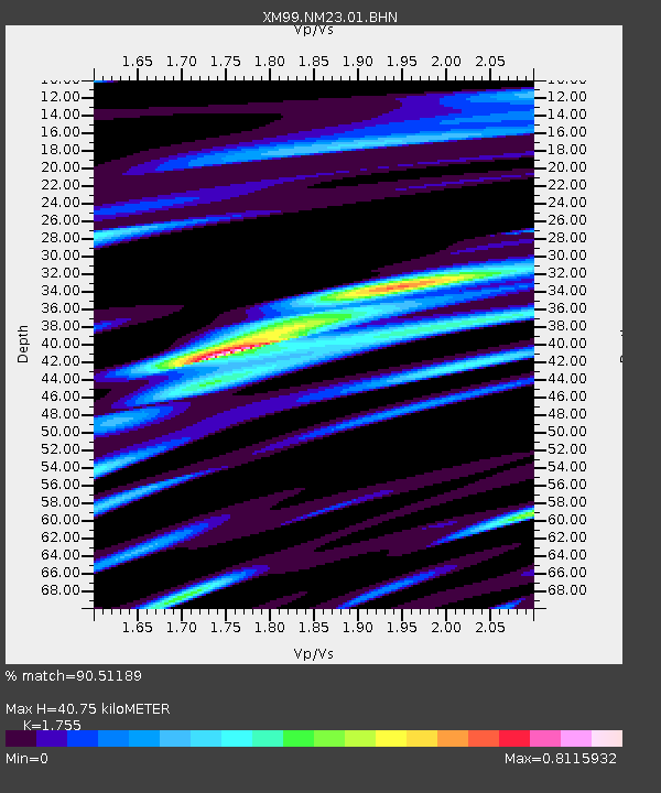
NM23 NewMexico23 - Earthquake Result Viewer
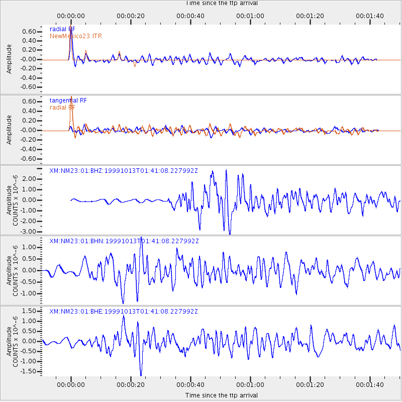
Earthquake location: Alaska Peninsula
Earthquake latitude/longitude: 54.7/-161.2
Earthquake time(UTC): 1999/10/13 (286) 01:33:40 GMT
Earthquake Depth: 30 km
Earthquake Magnitude: 6.0 MB, 6.2 MS, 6.5 MW, 6.0 ML
Earthquake Catalog/Contributor: WHDF/NEIC
Network: XM Rio Grande Seismic Transect
Station: NM23 NewMexico23
Lat/Lon: 33.95 N/106.01 W
Elevation: 1813 m
Distance: 43.3 deg
Az: 95.302 deg
Baz: 315.891 deg
Ray Param: 0.07260811
Estimated Moho Depth: 40.75 km
Estimated Crust Vp/Vs: 1.75
Assumed Crust Vp: 6.502 km/s
Estimated Crust Vs: 3.705 km/s
Estimated Crust Poisson's Ratio: 0.26
Radial Match: 90.51189 %
Radial Bump: 400
Transverse Match: 76.56635 %
Transverse Bump: 400
SOD ConfigId: 27569
Insert Time: 2010-02-26 17:34:48.973 +0000
GWidth: 2.5
Max Bumps: 400
Tol: 0.001

Signal To Noise

ChannelStoNSTALTA
XM:NM23:01:BHN:19991013T01:41:08.227992Z3.73268342.6170935E-77.0112925E-8
XM:NM23:01:BHE:19991013T01:41:08.227992Z1.3739481.4970499E-71.0895972E-7
XM:NM23:01:BHZ:19991013T01:41:08.227992Z2.67132193.2223215E-71.2062648E-7
Arrivals
Ps5.1 SECOND
PpPs16 SECOND
PsPs/PpSs21 SECOND