You are here: Home > Network List > UU - University of Utah Regional Network Stations List
> Station SPU South Promontory Point, UT, USA > Earthquake Result Viewer
SPU South Promontory Point, UT, USA - Earthquake Result Viewer
| Earthquake location: |
Fiji Islands Region |
| Earthquake latitude/longitude: |
-17.0/-178.0 |
| Earthquake time(UTC): |
2018/08/19 (231) 04:28:58 GMT |
| Earthquake Depth: |
416 km |
| Earthquake Magnitude: |
6.8 mww |
| Earthquake Catalog/Contributor: |
NEIC PDE/us |
|
| Network: |
UU University of Utah Regional Network |
| Station: |
SPU South Promontory Point, UT, USA |
| Lat/Lon: |
41.31 N/112.45 W |
| Elevation: |
2086 m |
|
| Distance: |
83.8 deg |
| Az: |
43.627 deg |
| Baz: |
241.214 deg |
| Ray Param: |
0.04477214 |
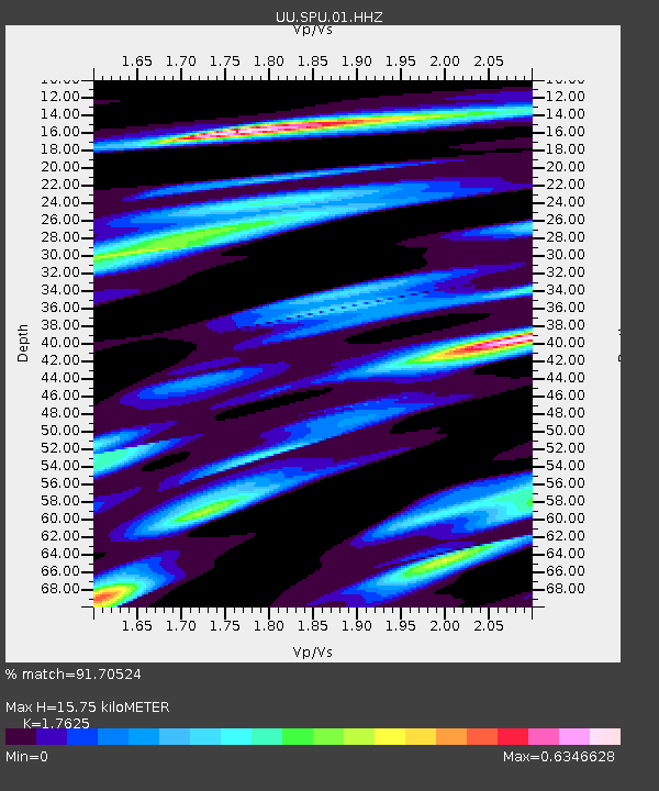
| Estimated Moho Depth: |
15.75 km |
| Estimated Crust Vp/Vs: |
1.76 |
| Assumed Crust Vp: |
6.276 km/s |
| Estimated Crust Vs: |
3.561 km/s |
| Estimated Crust Poisson's Ratio: |
0.26 |
|
| Radial Match: |
91.70524 % |
| Radial Bump: |
369 |
| Transverse Match: |
85.60079 % |
| Transverse Bump: |
392 |
| SOD ConfigId: |
2825771 |
| Insert Time: |
2018-09-02 04:36:33.423 +0000 |
| GWidth: |
2.5 |
| Max Bumps: |
400 |
| Tol: |
0.001 |
|

Signal To Noise
| Channel | StoN | STA | LTA |
| UU:SPU:01:HHZ:20180819T04:40:11.884998Z | 15.521281 | 1.2643272E-7 | 8.145766E-9 |
| UU:SPU:01:HHN:20180819T04:40:11.884998Z | 2.9839482 | 1.691548E-8 | 5.668825E-9 |
| UU:SPU:01:HHE:20180819T04:40:11.884998Z | 5.9436183 | 4.44825E-8 | 7.484077E-9 |
| Arrivals |
| Ps | 2.0 SECOND |
| PpPs | 6.8 SECOND |
| PsPs/PpSs | 8.7 SECOND |


