You are here: Home > Network List > N4 - Central and EAstern US Network Stations List
> Station U49A Red Boiling Springs, TN, USA > Earthquake Result Viewer
U49A Red Boiling Springs, TN, USA - Earthquake Result Viewer
| Earthquake location: |
Near Coast Of Ecuador |
| Earthquake latitude/longitude: |
-2.1/-79.8 |
| Earthquake time(UTC): |
2022/07/14 (195) 22:30:13 GMT |
| Earthquake Depth: |
81 km |
| Earthquake Magnitude: |
5.7 mww |
| Earthquake Catalog/Contributor: |
NEIC PDE/us |
|
| Network: |
N4 Central and EAstern US Network |
| Station: |
U49A Red Boiling Springs, TN, USA |
| Lat/Lon: |
36.51 N/85.78 W |
| Elevation: |
234 m |
|
| Distance: |
38.8 deg |
| Az: |
352.269 deg |
| Baz: |
170.394 deg |
| Ray Param: |
0.07513065 |
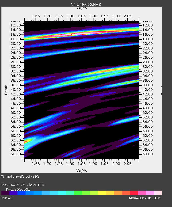
| Estimated Moho Depth: |
15.75 km |
| Estimated Crust Vp/Vs: |
1.81 |
| Assumed Crust Vp: |
6.476 km/s |
| Estimated Crust Vs: |
3.588 km/s |
| Estimated Crust Poisson's Ratio: |
0.28 |
|
| Radial Match: |
85.537895 % |
| Radial Bump: |
348 |
| Transverse Match: |
60.935406 % |
| Transverse Bump: |
400 |
| SOD ConfigId: |
28208852 |
| Insert Time: |
2022-07-28 23:07:10.538 +0000 |
| GWidth: |
2.5 |
| Max Bumps: |
400 |
| Tol: |
0.001 |
|

Signal To Noise
| Channel | StoN | STA | LTA |
| N4:U49A:00:HHZ:20220714T22:36:59.458995Z | 7.0012603 | 1.1247537E-6 | 1.6065019E-7 |
| N4:U49A:00:HH1:20220714T22:36:59.458995Z | 5.084753 | 5.9876027E-7 | 1.17756024E-7 |
| N4:U49A:00:HH2:20220714T22:36:59.458995Z | 1.6431683 | 1.887343E-7 | 1.1485999E-7 |
| Arrivals |
| Ps | 2.1 SECOND |
| PpPs | 6.4 SECOND |
| PsPs/PpSs | 8.5 SECOND |


