You are here: Home > Network List > N4 - Central and EAstern US Network Stations List
> Station Z35B Perchaven, Sanger, TX, USA > Earthquake Result Viewer
Z35B Perchaven, Sanger, TX, USA - Earthquake Result Viewer
| Earthquake location: |
Near Coast Of Ecuador |
| Earthquake latitude/longitude: |
-2.1/-79.8 |
| Earthquake time(UTC): |
2022/07/14 (195) 22:30:13 GMT |
| Earthquake Depth: |
81 km |
| Earthquake Magnitude: |
5.7 mww |
| Earthquake Catalog/Contributor: |
NEIC PDE/us |
|
| Network: |
N4 Central and EAstern US Network |
| Station: |
Z35B Perchaven, Sanger, TX, USA |
| Lat/Lon: |
33.33 N/97.25 W |
| Elevation: |
234 m |
|
| Distance: |
38.9 deg |
| Az: |
336.384 deg |
| Baz: |
151.431 deg |
| Ray Param: |
0.07507335 |
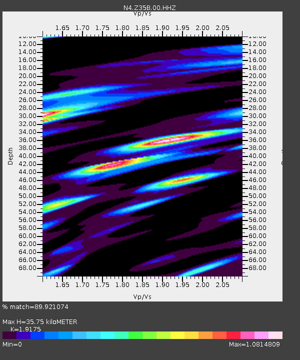
| Estimated Moho Depth: |
35.75 km |
| Estimated Crust Vp/Vs: |
1.92 |
| Assumed Crust Vp: |
6.38 km/s |
| Estimated Crust Vs: |
3.328 km/s |
| Estimated Crust Poisson's Ratio: |
0.31 |
|
| Radial Match: |
89.921074 % |
| Radial Bump: |
283 |
| Transverse Match: |
72.49643 % |
| Transverse Bump: |
400 |
| SOD ConfigId: |
28208852 |
| Insert Time: |
2022-07-28 23:07:41.859 +0000 |
| GWidth: |
2.5 |
| Max Bumps: |
400 |
| Tol: |
0.001 |
|

Signal To Noise
| Channel | StoN | STA | LTA |
| N4:Z35B:00:HHZ:20220714T22:37:00.240001Z | 22.89093 | 2.2486147E-6 | 9.823169E-8 |
| N4:Z35B:00:HH1:20220714T22:37:00.240001Z | 12.0419445 | 1.6427024E-6 | 1.3641505E-7 |
| N4:Z35B:00:HH2:20220714T22:37:00.240001Z | 3.616461 | 6.9677446E-7 | 1.9266749E-7 |
| Arrivals |
| Ps | 5.5 SECOND |
| PpPs | 15 SECOND |
| PsPs/PpSs | 21 SECOND |


