You are here: Home > Network List > 4T - Texas Seismological Network (TexNet Stations) Stations List
> Station NM01 Eunice > Earthquake Result Viewer
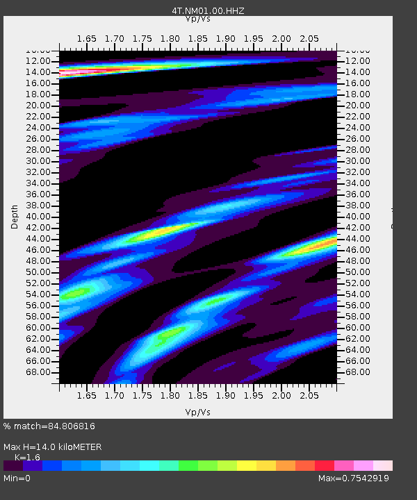
NM01 Eunice - Earthquake Result Viewer
| Earthquake location: |
Fiji Islands Region |
| Earthquake latitude/longitude: |
-17.0/-178.0 |
| Earthquake time(UTC): |
2018/08/19 (231) 04:28:58 GMT |
| Earthquake Depth: |
416 km |
| Earthquake Magnitude: |
6.8 mww |
| Earthquake Catalog/Contributor: |
NEIC PDE/us |
|
| Network: |
4T Texas Seismological Network (TexNet Stations) |
| Station: |
NM01 Eunice |
| Lat/Lon: |
32.36 N/103.40 W |
| Elevation: |
1051 m |
|
| Distance: |
86.6 deg |
| Az: |
54.844 deg |
| Baz: |
247.581 deg |
| Ray Param: |
0.042869166 |
| Estimated Moho Depth: |
14.0 km |
| Estimated Crust Vp/Vs: |
1.60 |
| Assumed Crust Vp: |
6.129 km/s |
| Estimated Crust Vs: |
3.831 km/s |
| Estimated Crust Poisson's Ratio: |
0.18 |
|
| Radial Match: |
84.806816 % |
| Radial Bump: |
400 |
| Transverse Match: |
61.930717 % |
| Transverse Bump: |
400 |
| SOD ConfigId: |
2825771 |
| Insert Time: |
2018-09-02 04:37:37.058 +0000 |
| GWidth: |
2.5 |
| Max Bumps: |
400 |
| Tol: |
0.001 |
|

Signal To Noise
| Channel | StoN | STA | LTA |
| 4T:NM01:00:HHZ:20180819T04:40:25.069995Z | 17.839443 | 3.951129E-6 | 2.2148276E-7 |
| 4T:NM01:00:HH1:20180819T04:40:25.069995Z | 3.525005 | 5.388687E-7 | 1.5287033E-7 |
| 4T:NM01:00:HH2:20180819T04:40:25.069995Z | 6.427989 | 1.325485E-6 | 2.0620523E-7 |
| Arrivals |
| Ps | 1.4 SECOND |
| PpPs | 5.8 SECOND |
| PsPs/PpSs | 7.2 SECOND |


