You are here: Home > Network List > TX - Texas Seismological Network Stations List
> Station 435B Jarrell, TX, USA > Earthquake Result Viewer
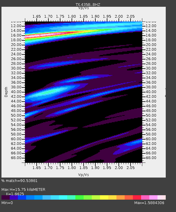
435B Jarrell, TX, USA - Earthquake Result Viewer
| Earthquake location: |
Near Coast Of Ecuador |
| Earthquake latitude/longitude: |
-2.1/-79.8 |
| Earthquake time(UTC): |
2022/07/14 (195) 22:30:13 GMT |
| Earthquake Depth: |
81 km |
| Earthquake Magnitude: |
5.7 mww |
| Earthquake Catalog/Contributor: |
NEIC PDE/us |
|
| Network: |
TX Texas Seismological Network |
| Station: |
435B Jarrell, TX, USA |
| Lat/Lon: |
30.78 N/97.58 W |
| Elevation: |
248 m |
|
| Distance: |
36.8 deg |
| Az: |
333.937 deg |
| Baz: |
149.323 deg |
| Ray Param: |
0.076253094 |
| Estimated Moho Depth: |
15.75 km |
| Estimated Crust Vp/Vs: |
1.66 |
| Assumed Crust Vp: |
6.347 km/s |
| Estimated Crust Vs: |
3.818 km/s |
| Estimated Crust Poisson's Ratio: |
0.22 |
|
| Radial Match: |
90.53981 % |
| Radial Bump: |
309 |
| Transverse Match: |
80.34259 % |
| Transverse Bump: |
400 |
| SOD ConfigId: |
28208852 |
| Insert Time: |
2022-07-28 23:16:44.418 +0000 |
| GWidth: |
2.5 |
| Max Bumps: |
400 |
| Tol: |
0.001 |
|

Signal To Noise
| Channel | StoN | STA | LTA |
| TX:435B: :BHZ:20220714T22:36:42.84901Z | 18.182524 | 1.8849676E-6 | 1.036692E-7 |
| TX:435B: :BHN:20220714T22:36:42.84901Z | 8.640696 | 9.79623E-7 | 1.1337316E-7 |
| TX:435B: :BHE:20220714T22:36:42.84901Z | 4.567727 | 6.630836E-7 | 1.4516708E-7 |
| Arrivals |
| Ps | 1.8 SECOND |
| PpPs | 6.1 SECOND |
| PsPs/PpSs | 7.9 SECOND |


