You are here: Home > Network List > IU - Global Seismograph Network (GSN - IRIS/USGS) Stations List
> Station POHA Pohakuloa, Hawaii, USA > Earthquake Result Viewer
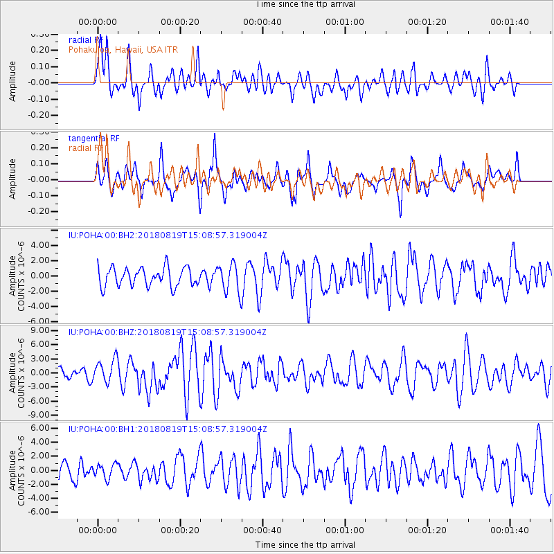
POHA Pohakuloa, Hawaii, USA - Earthquake Result Viewer
*The percent match for this event was below the threshold and hence no stack was calculated.
| Earthquake location: |
Sumbawa Region, Indonesia |
| Earthquake latitude/longitude: |
-8.3/116.6 |
| Earthquake time(UTC): |
2018/08/19 (231) 14:56:28 GMT |
| Earthquake Depth: |
26 km |
| Earthquake Magnitude: |
6.9 Mww |
| Earthquake Catalog/Contributor: |
NEIC PDE/us |
|
| Network: |
IU Global Seismograph Network (GSN - IRIS/USGS) |
| Station: |
POHA Pohakuloa, Hawaii, USA |
| Lat/Lon: |
19.76 N/155.53 W |
| Elevation: |
1990 m |
|
| Distance: |
90.8 deg |
| Az: |
70.265 deg |
| Baz: |
261.489 deg |
| Ray Param: |
$rayparam |
*The percent match for this event was below the threshold and hence was not used in the summary stack. |
|
| Radial Match: |
56.225285 % |
| Radial Bump: |
400 |
| Transverse Match: |
58.888668 % |
| Transverse Bump: |
400 |
| SOD ConfigId: |
2825771 |
| Insert Time: |
2018-09-02 15:07:10.982 +0000 |
| GWidth: |
2.5 |
| Max Bumps: |
400 |
| Tol: |
0.001 |
|
Signal To Noise
| Channel | StoN | STA | LTA |
| IU:POHA:00:BHZ:20180819T15:08:57.319004Z | 2.2424197 | 2.5304555E-6 | 1.1284486E-6 |
| IU:POHA:00:BH1:20180819T15:08:57.319004Z | 0.7792417 | 1.0277763E-6 | 1.3189442E-6 |
| IU:POHA:00:BH2:20180819T15:08:57.319004Z | 1.5769445 | 1.915845E-6 | 1.2149096E-6 |
| Arrivals |
| Ps | |
| PpPs | |
| PsPs/PpSs | |


