You are here: Home > Network List > UW - Pacific Northwest Regional Seismic Network Stations List
> Station DAVN Davenport, WA, USA > Earthquake Result Viewer
DAVN Davenport, WA, USA - Earthquake Result Viewer

| Earthquake location: |
Near Coast Of Ecuador |
| Earthquake latitude/longitude: |
-2.1/-79.8 |
| Earthquake time(UTC): |
2022/07/14 (195) 22:30:13 GMT |
| Earthquake Depth: |
81 km |
| Earthquake Magnitude: |
5.7 mww |
| Earthquake Catalog/Contributor: |
NEIC PDE/us |
|
| Network: |
UW Pacific Northwest Regional Seismic Network |
| Station: |
DAVN Davenport, WA, USA |
| Lat/Lon: |
47.80 N/118.27 W |
| Elevation: |
483 m |
|
| Distance: |
59.9 deg |
| Az: |
330.994 deg |
| Baz: |
134.046 deg |
| Ray Param: |
0.061649144 |
| Estimated Moho Depth: |
61.25 km |
| Estimated Crust Vp/Vs: |
2.10 |
| Assumed Crust Vp: |
6.419 km/s |
| Estimated Crust Vs: |
3.06 km/s |
| Estimated Crust Poisson's Ratio: |
0.35 |
|
| Radial Match: |
96.73141 % |
| Radial Bump: |
153 |
| Transverse Match: |
61.260307 % |
| Transverse Bump: |
400 |
| SOD ConfigId: |
28208852 |
| Insert Time: |
2022-07-28 23:22:45.393 +0000 |
| GWidth: |
2.5 |
| Max Bumps: |
400 |
| Tol: |
0.001 |
|
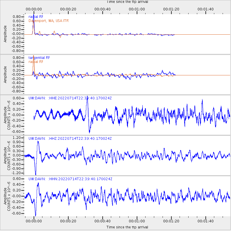
Signal To Noise
| Channel | StoN | STA | LTA |
| UW:DAVN: :HHZ:20220714T22:39:40.170024Z | 4.9783635 | 6.0433285E-7 | 1.2139188E-7 |
| UW:DAVN: :HHN:20220714T22:39:40.170024Z | 3.209919 | 3.154776E-7 | 9.828211E-8 |
| UW:DAVN: :HHE:20220714T22:39:40.170024Z | 3.744578 | 3.451281E-7 | 9.216742E-8 |
| Arrivals |
| Ps | 11 SECOND |
| PpPs | 28 SECOND |
| PsPs/PpSs | 39 SECOND |


