You are here: Home > Network List > GS - US Geological Survey Networks Stations List
> Station DEC05 Apollo Drive Surface Site > Earthquake Result Viewer
DEC05 Apollo Drive Surface Site - Earthquake Result Viewer
| Earthquake location: |
Tonga Islands Region |
| Earthquake latitude/longitude: |
-17.6/-172.8 |
| Earthquake time(UTC): |
2022/07/16 (197) 03:25:48 GMT |
| Earthquake Depth: |
10 km |
| Earthquake Magnitude: |
5.3 mww |
| Earthquake Catalog/Contributor: |
NEIC PDE/us |
|
| Network: |
GS US Geological Survey Networks |
| Station: |
DEC05 Apollo Drive Surface Site |
| Lat/Lon: |
39.87 N/88.87 W |
| Elevation: |
216 m |
|
| Distance: |
96.6 deg |
| Az: |
50.4 deg |
| Baz: |
252.69 deg |
| Ray Param: |
0.04046277 |
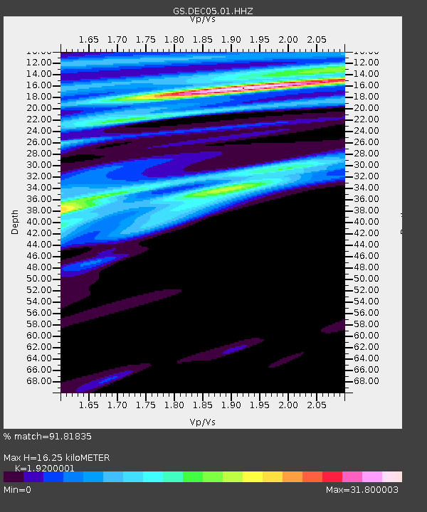
| Estimated Moho Depth: |
16.25 km |
| Estimated Crust Vp/Vs: |
1.92 |
| Assumed Crust Vp: |
6.444 km/s |
| Estimated Crust Vs: |
3.356 km/s |
| Estimated Crust Poisson's Ratio: |
0.31 |
|
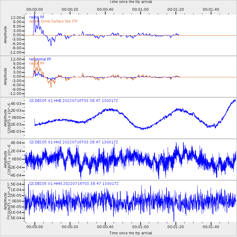
| Radial Match: |
91.81835 % |
| Radial Bump: |
257 |
| Transverse Match: |
91.58386 % |
| Transverse Bump: |
272 |
| SOD ConfigId: |
28208852 |
| Insert Time: |
2022-07-30 03:39:38.727 +0000 |
| GWidth: |
2.5 |
| Max Bumps: |
400 |
| Tol: |
0.001 |
|
Signal To Noise
| Channel | StoN | STA | LTA |
| GS:DEC05:01:HHZ:20220716T03:38:47.130017Z | 0.96711046 | 9.6584025E-11 | 9.9868655E-11 |
| GS:DEC05:01:HHN:20220716T03:38:47.130017Z | 1.0153136 | 4.142294E-11 | 4.0798174E-11 |
| GS:DEC05:01:HHE:20220716T03:38:47.130017Z | 1.9731939 | 9.409447E-10 | 4.768637E-10 |
| Arrivals |
| Ps | 2.4 SECOND |
| PpPs | 7.2 SECOND |
| PsPs/PpSs | 9.6 SECOND |


