You are here: Home > Network List > IU - Global Seismograph Network (GSN - IRIS/USGS) Stations List
> Station JOHN Johnston Island, USA > Earthquake Result Viewer
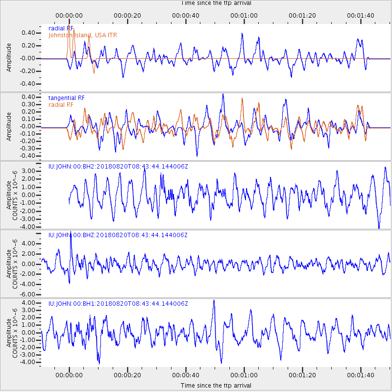
JOHN Johnston Island, USA - Earthquake Result Viewer
*The percent match for this event was below the threshold and hence no stack was calculated.
| Earthquake location: |
Fiji Islands Region |
| Earthquake latitude/longitude: |
-18.2/-178.2 |
| Earthquake time(UTC): |
2018/08/20 (232) 08:38:00 GMT |
| Earthquake Depth: |
528 km |
| Earthquake Magnitude: |
5.5 Mww |
| Earthquake Catalog/Contributor: |
NEIC PDE/us |
|
| Network: |
IU Global Seismograph Network (GSN - IRIS/USGS) |
| Station: |
JOHN Johnston Island, USA |
| Lat/Lon: |
16.73 N/169.53 W |
| Elevation: |
2.0 m |
|
| Distance: |
35.8 deg |
| Az: |
14.258 deg |
| Baz: |
194.139 deg |
| Ray Param: |
$rayparam |
*The percent match for this event was below the threshold and hence was not used in the summary stack. |
|
| Radial Match: |
55.103756 % |
| Radial Bump: |
400 |
| Transverse Match: |
58.416786 % |
| Transverse Bump: |
400 |
| SOD ConfigId: |
2825771 |
| Insert Time: |
2018-09-03 08:43:23.784 +0000 |
| GWidth: |
2.5 |
| Max Bumps: |
400 |
| Tol: |
0.001 |
|
Signal To Noise
| Channel | StoN | STA | LTA |
| IU:JOHN:00:BHZ:20180820T08:43:44.144006Z | 2.173114 | 2.0315103E-6 | 9.348384E-7 |
| IU:JOHN:00:BH1:20180820T08:43:44.144006Z | 0.78357774 | 1.0066955E-6 | 1.2847423E-6 |
| IU:JOHN:00:BH2:20180820T08:43:44.144006Z | 0.9517487 | 1.3763972E-6 | 1.4461771E-6 |
| Arrivals |
| Ps | |
| PpPs | |
| PsPs/PpSs | |


