You are here: Home > Network List > XK99 - CDROM (Colorado) Stations List
> Station N06 North 06 > Earthquake Result Viewer
N06 North 06 - Earthquake Result Viewer
| Earthquake location: |
Tonga Islands |
| Earthquake latitude/longitude: |
-16.9/-174.2 |
| Earthquake time(UTC): |
2000/01/08 (008) 16:47:20 GMT |
| Earthquake Depth: |
183 km |
| Earthquake Magnitude: |
6.5 MB, 6.6 MS, 7.2 MW, 7.0 ME |
| Earthquake Catalog/Contributor: |
WHDF/NEIC |
|
| Network: |
XK CDROM (Colorado) |
| Station: |
N06 North 06 |
| Lat/Lon: |
41.80 N/107.35 W |
| Elevation: |
2136 m |
|
| Distance: |
84.9 deg |
| Az: |
43.664 deg |
| Baz: |
242.119 deg |
| Ray Param: |
0.04471172 |
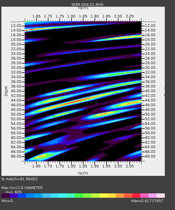
| Estimated Moho Depth: |
13.5 km |
| Estimated Crust Vp/Vs: |
1.61 |
| Assumed Crust Vp: |
6.159 km/s |
| Estimated Crust Vs: |
3.837 km/s |
| Estimated Crust Poisson's Ratio: |
0.18 |
|
| Radial Match: |
91.96482 % |
| Radial Bump: |
400 |
| Transverse Match: |
87.22178 % |
| Transverse Bump: |
400 |
| SOD ConfigId: |
287362 |
| Insert Time: |
2010-03-09 22:39:05.342 +0000 |
| GWidth: |
2.5 |
| Max Bumps: |
400 |
| Tol: |
0.001 |
|

Signal To Noise
| Channel | StoN | STA | LTA |
| XK:N06:01:BHN:20000108T16:59:03.647017Z | 2.339608 | 9.0759534E-7 | 3.8792626E-7 |
| XK:N06:01:BHE:20000108T16:59:03.647017Z | 2.7307446 | 1.4426357E-6 | 5.282939E-7 |
| XK:N06:01:BHZ:20000108T16:59:03.647017Z | 13.407333 | 4.5287848E-6 | 3.3778414E-7 |
| Arrivals |
| Ps | 1.4 SECOND |
| PpPs | 5.6 SECOND |
| PsPs/PpSs | 6.9 SECOND |


