You are here: Home > Network List > US - United States National Seismic Network Stations List
> Station BOZ Bozeman, Montana, USA > Earthquake Result Viewer
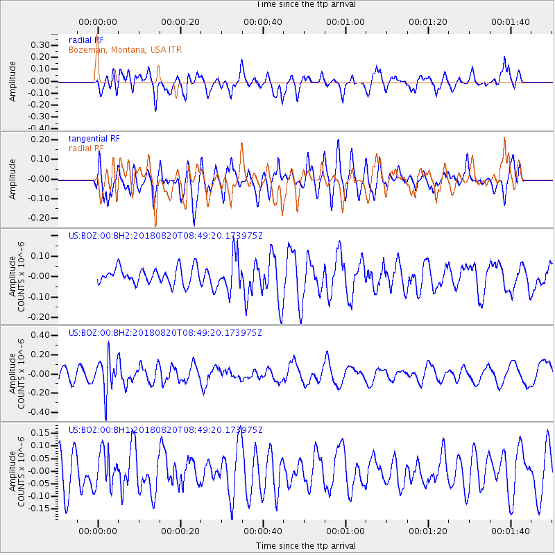
BOZ Bozeman, Montana, USA - Earthquake Result Viewer
*The percent match for this event was below the threshold and hence no stack was calculated.
| Earthquake location: |
Fiji Islands Region |
| Earthquake latitude/longitude: |
-18.2/-178.2 |
| Earthquake time(UTC): |
2018/08/20 (232) 08:38:00 GMT |
| Earthquake Depth: |
528 km |
| Earthquake Magnitude: |
5.5 Mww |
| Earthquake Catalog/Contributor: |
NEIC PDE/us |
|
| Network: |
US United States National Seismic Network |
| Station: |
BOZ Bozeman, Montana, USA |
| Lat/Lon: |
45.65 N/111.63 W |
| Elevation: |
1589 m |
|
| Distance: |
87.5 deg |
| Az: |
40.1 deg |
| Baz: |
240.767 deg |
| Ray Param: |
$rayparam |
*The percent match for this event was below the threshold and hence was not used in the summary stack. |
|
| Radial Match: |
46.140842 % |
| Radial Bump: |
400 |
| Transverse Match: |
49.446194 % |
| Transverse Bump: |
400 |
| SOD ConfigId: |
2825771 |
| Insert Time: |
2018-09-03 08:45:15.863 +0000 |
| GWidth: |
2.5 |
| Max Bumps: |
400 |
| Tol: |
0.001 |
|
Signal To Noise
| Channel | StoN | STA | LTA |
| US:BOZ:00:BHZ:20180820T08:49:20.173975Z | 2.4388719 | 1.716652E-7 | 7.038714E-8 |
| US:BOZ:00:BH1:20180820T08:49:20.173975Z | 1.0763217 | 6.9310865E-8 | 6.439605E-8 |
| US:BOZ:00:BH2:20180820T08:49:20.173975Z | 2.185163 | 8.539536E-8 | 3.9079627E-8 |
| Arrivals |
| Ps | |
| PpPs | |
| PsPs/PpSs | |


