You are here: Home > Network List > US - United States National Seismic Network Stations List
> Station HAWA Hanford, Washington, USA > Earthquake Result Viewer
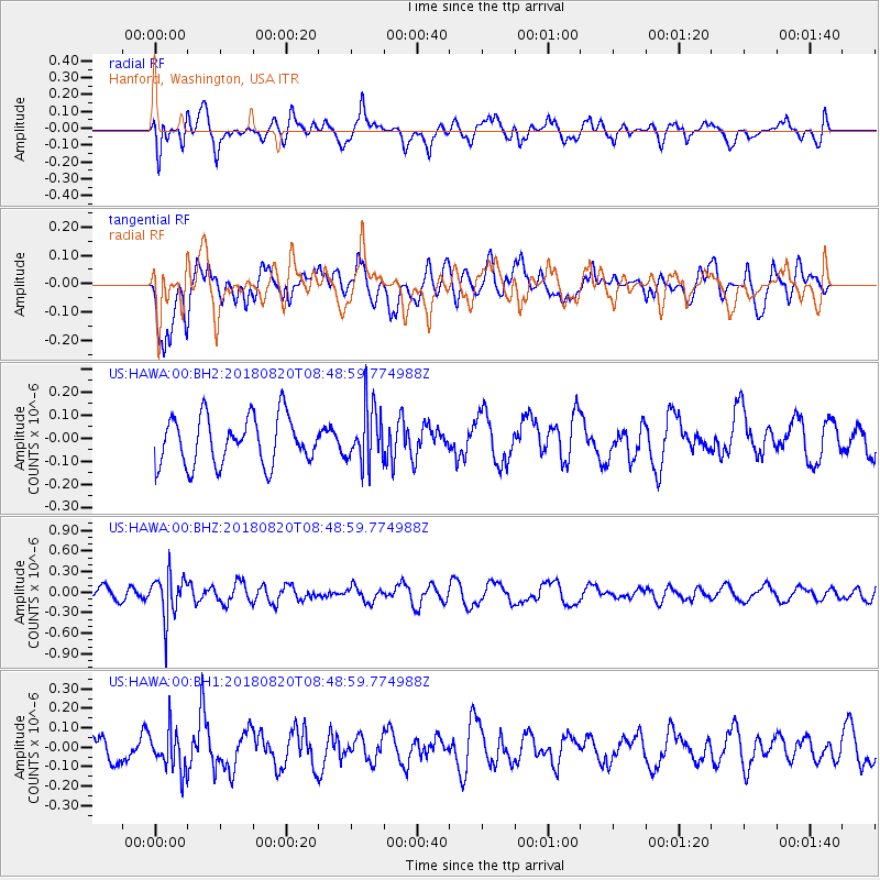
HAWA Hanford, Washington, USA - Earthquake Result Viewer
*The percent match for this event was below the threshold and hence no stack was calculated.
| Earthquake location: |
Fiji Islands Region |
| Earthquake latitude/longitude: |
-18.2/-178.2 |
| Earthquake time(UTC): |
2018/08/20 (232) 08:38:00 GMT |
| Earthquake Depth: |
528 km |
| Earthquake Magnitude: |
5.5 Mww |
| Earthquake Catalog/Contributor: |
NEIC PDE/us |
|
| Network: |
US United States National Seismic Network |
| Station: |
HAWA Hanford, Washington, USA |
| Lat/Lon: |
46.39 N/119.53 W |
| Elevation: |
364 m |
|
| Distance: |
83.2 deg |
| Az: |
36.525 deg |
| Baz: |
234.805 deg |
| Ray Param: |
$rayparam |
*The percent match for this event was below the threshold and hence was not used in the summary stack. |
|
| Radial Match: |
52.31093 % |
| Radial Bump: |
400 |
| Transverse Match: |
46.80478 % |
| Transverse Bump: |
400 |
| SOD ConfigId: |
2825771 |
| Insert Time: |
2018-09-03 08:45:26.223 +0000 |
| GWidth: |
2.5 |
| Max Bumps: |
400 |
| Tol: |
0.001 |
|
Signal To Noise
| Channel | StoN | STA | LTA |
| US:HAWA:00:BHZ:20180820T08:48:59.774988Z | 3.513416 | 3.2182925E-7 | 9.160009E-8 |
| US:HAWA:00:BH1:20180820T08:48:59.774988Z | 1.496918 | 1.04258866E-7 | 6.964902E-8 |
| US:HAWA:00:BH2:20180820T08:48:59.774988Z | 1.1930928 | 1.2371302E-7 | 1.0369103E-7 |
| Arrivals |
| Ps | |
| PpPs | |
| PsPs/PpSs | |


