You are here: Home > Network List > US - United States National Seismic Network Stations List
> Station CBKS Cedar Bluff, Kansas, USA > Earthquake Result Viewer
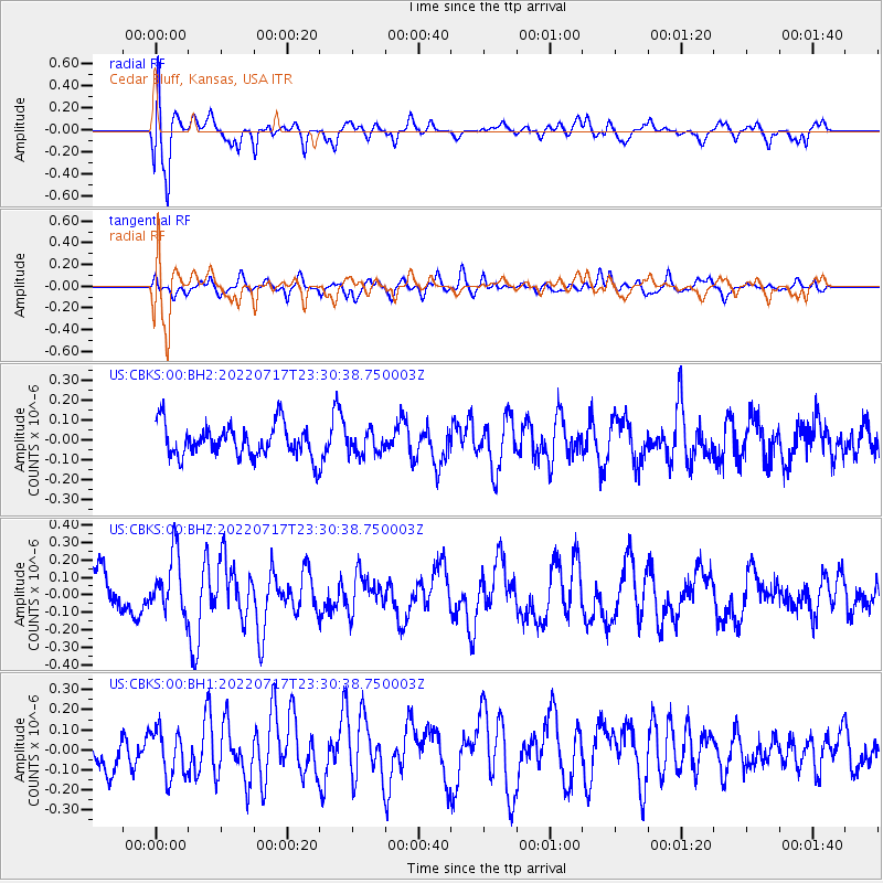
CBKS Cedar Bluff, Kansas, USA - Earthquake Result Viewer
*The percent match for this event was below the threshold and hence no stack was calculated.
| Earthquake location: |
Easter Island Region |
| Earthquake latitude/longitude: |
-22.5/-114.3 |
| Earthquake time(UTC): |
2022/07/17 (198) 23:20:46 GMT |
| Earthquake Depth: |
10 km |
| Earthquake Magnitude: |
5.5 Mww |
| Earthquake Catalog/Contributor: |
NEIC PDE/us |
|
| Network: |
US United States National Seismic Network |
| Station: |
CBKS Cedar Bluff, Kansas, USA |
| Lat/Lon: |
38.81 N/99.74 W |
| Elevation: |
677 m |
|
| Distance: |
62.5 deg |
| Az: |
12.758 deg |
| Baz: |
195.157 deg |
| Ray Param: |
$rayparam |
*The percent match for this event was below the threshold and hence was not used in the summary stack. |
|
| Radial Match: |
78.504036 % |
| Radial Bump: |
400 |
| Transverse Match: |
44.976738 % |
| Transverse Bump: |
400 |
| SOD ConfigId: |
28208852 |
| Insert Time: |
2022-07-31 23:47:06.358 +0000 |
| GWidth: |
2.5 |
| Max Bumps: |
400 |
| Tol: |
0.001 |
|
Signal To Noise
| Channel | StoN | STA | LTA |
| US:CBKS:00:BHZ:20220717T23:30:38.750003Z | 1.7432154 | 1.7026001E-7 | 9.767009E-8 |
| US:CBKS:00:BH1:20220717T23:30:38.750003Z | 1.2169237 | 1.1595144E-7 | 9.5282424E-8 |
| US:CBKS:00:BH2:20220717T23:30:38.750003Z | 0.7052014 | 5.779584E-8 | 8.195651E-8 |
| Arrivals |
| Ps | |
| PpPs | |
| PsPs/PpSs | |


