You are here: Home > Network List > AK - Alaska Regional Network Stations List
> Station H23K Yukon River, AK, USA > Earthquake Result Viewer
H23K Yukon River, AK, USA - Earthquake Result Viewer
| Earthquake location: |
Svalbard Region |
| Earthquake latitude/longitude: |
78.6/6.0 |
| Earthquake time(UTC): |
2022/07/18 (199) 18:40:32 GMT |
| Earthquake Depth: |
10 km |
| Earthquake Magnitude: |
5.9 Mww |
| Earthquake Catalog/Contributor: |
NEIC PDE/us |
|
| Network: |
AK Alaska Regional Network |
| Station: |
H23K Yukon River, AK, USA |
| Lat/Lon: |
65.83 N/149.54 W |
| Elevation: |
617 m |
|
| Distance: |
35.0 deg |
| Az: |
342.747 deg |
| Baz: |
8.208 deg |
| Ray Param: |
0.07744299 |
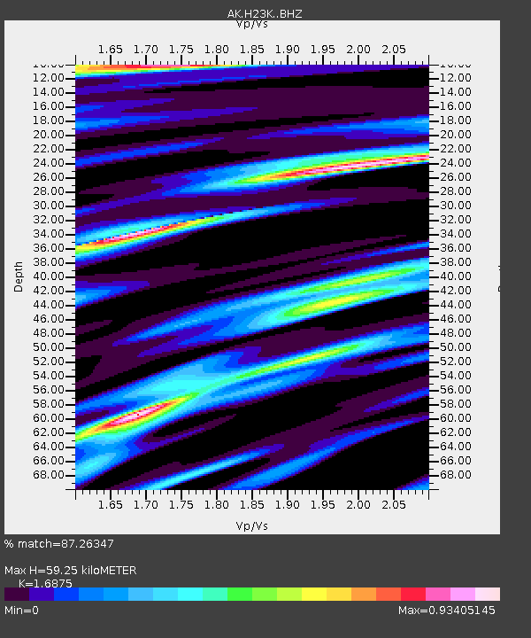
| Estimated Moho Depth: |
59.25 km |
| Estimated Crust Vp/Vs: |
1.69 |
| Assumed Crust Vp: |
6.566 km/s |
| Estimated Crust Vs: |
3.891 km/s |
| Estimated Crust Poisson's Ratio: |
0.23 |
|
| Radial Match: |
87.26347 % |
| Radial Bump: |
299 |
| Transverse Match: |
63.744045 % |
| Transverse Bump: |
400 |
| SOD ConfigId: |
28208852 |
| Insert Time: |
2022-08-01 18:43:42.617 +0000 |
| GWidth: |
2.5 |
| Max Bumps: |
400 |
| Tol: |
0.001 |
|

Signal To Noise
| Channel | StoN | STA | LTA |
| AK:H23K: :BHZ:20220718T18:46:54.840001Z | 2.360068 | 2.3566187E-7 | 9.985385E-8 |
| AK:H23K: :BHN:20220718T18:46:54.840001Z | 1.00123 | 1.1797122E-7 | 1.1782628E-7 |
| AK:H23K: :BHE:20220718T18:46:54.840001Z | 0.93821394 | 1.1264069E-7 | 1.2005864E-7 |
| Arrivals |
| Ps | 6.7 SECOND |
| PpPs | 22 SECOND |
| PsPs/PpSs | 29 SECOND |


