You are here: Home > Network List > CO - South Carolina Seismic Network Stations List
> Station CASEE Lake Jocassee, SC, USA > Earthquake Result Viewer
CASEE Lake Jocassee, SC, USA - Earthquake Result Viewer
| Earthquake location: |
Near Coast Of Venezuela |
| Earthquake latitude/longitude: |
10.9/-62.9 |
| Earthquake time(UTC): |
2018/08/21 (233) 21:31:46 GMT |
| Earthquake Depth: |
154 km |
| Earthquake Magnitude: |
7.3 Mww |
| Earthquake Catalog/Contributor: |
NEIC PDE/us |
|
| Network: |
CO South Carolina Seismic Network |
| Station: |
CASEE Lake Jocassee, SC, USA |
| Lat/Lon: |
34.99 N/82.93 W |
| Elevation: |
385 m |
|
| Distance: |
30.2 deg |
| Az: |
325.949 deg |
| Baz: |
137.938 deg |
| Ray Param: |
0.079123706 |
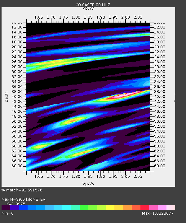
| Estimated Moho Depth: |
39.0 km |
| Estimated Crust Vp/Vs: |
2.00 |
| Assumed Crust Vp: |
6.35 km/s |
| Estimated Crust Vs: |
3.179 km/s |
| Estimated Crust Poisson's Ratio: |
0.33 |
|
| Radial Match: |
92.591576 % |
| Radial Bump: |
296 |
| Transverse Match: |
70.03253 % |
| Transverse Bump: |
400 |
| SOD ConfigId: |
2825771 |
| Insert Time: |
2018-09-04 21:44:46.854 +0000 |
| GWidth: |
2.5 |
| Max Bumps: |
400 |
| Tol: |
0.001 |
|

Signal To Noise
| Channel | StoN | STA | LTA |
| CO:CASEE:00:HHZ:20180821T21:37:11.498009Z | 26.897844 | 6.125851E-6 | 2.2774506E-7 |
| CO:CASEE:00:HHN:20180821T21:37:11.498009Z | 6.112677 | 3.3455585E-6 | 5.4731476E-7 |
| CO:CASEE:00:HHE:20180821T21:37:11.498009Z | 24.51931 | 2.9361265E-6 | 1.1974753E-7 |
| Arrivals |
| Ps | 6.6 SECOND |
| PpPs | 17 SECOND |
| PsPs/PpSs | 24 SECOND |


