You are here: Home > Network List > G - GEOSCOPE Stations List
> Station MBO M'Bour, Senegal > Earthquake Result Viewer
MBO M'Bour, Senegal - Earthquake Result Viewer
| Earthquake location: |
Near Coast Of Venezuela |
| Earthquake latitude/longitude: |
10.9/-62.9 |
| Earthquake time(UTC): |
2018/08/21 (233) 21:31:46 GMT |
| Earthquake Depth: |
154 km |
| Earthquake Magnitude: |
7.3 Mww |
| Earthquake Catalog/Contributor: |
NEIC PDE/us |
|
| Network: |
G GEOSCOPE |
| Station: |
MBO M'Bour, Senegal |
| Lat/Lon: |
14.39 N/16.95 W |
| Elevation: |
3.0 m |
|
| Distance: |
44.9 deg |
| Az: |
80.501 deg |
| Baz: |
271.02 deg |
| Ray Param: |
0.07104513 |
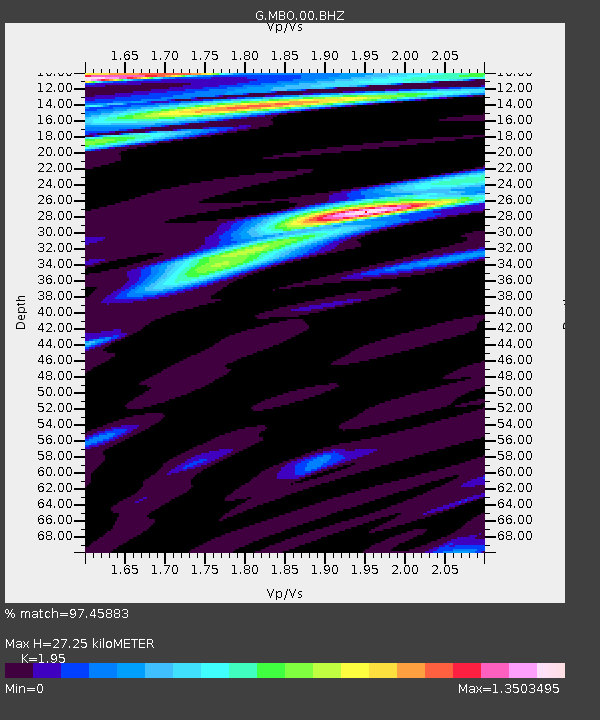
| Estimated Moho Depth: |
27.25 km |
| Estimated Crust Vp/Vs: |
1.95 |
| Assumed Crust Vp: |
5.55 km/s |
| Estimated Crust Vs: |
2.846 km/s |
| Estimated Crust Poisson's Ratio: |
0.32 |
|
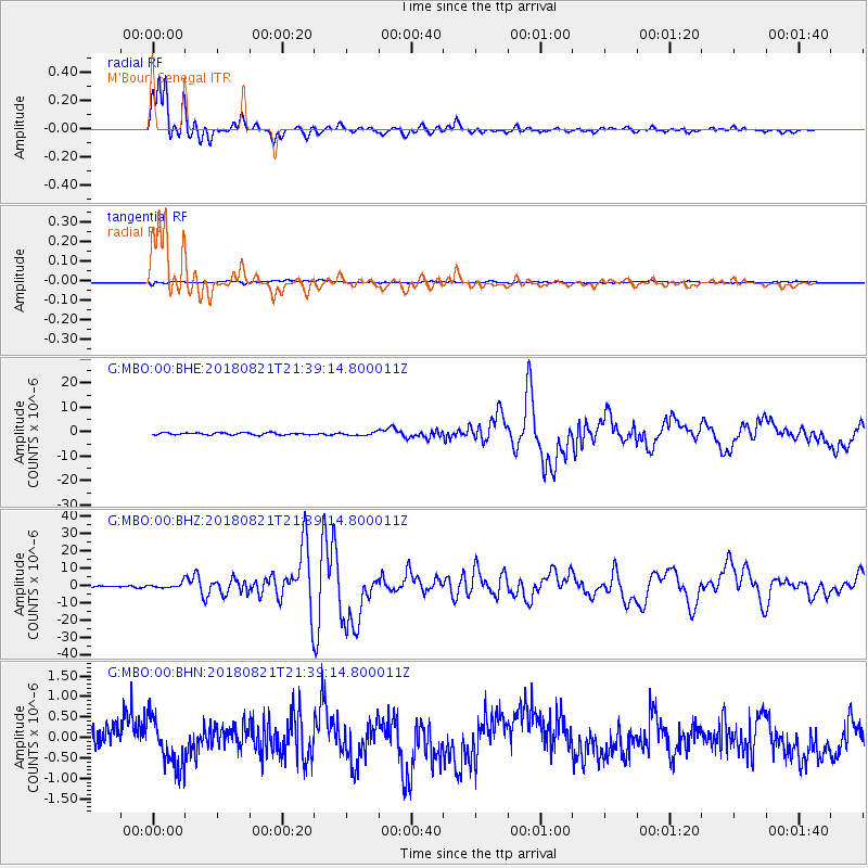
| Radial Match: |
97.45883 % |
| Radial Bump: |
299 |
| Transverse Match: |
42.733875 % |
| Transverse Bump: |
400 |
| SOD ConfigId: |
2825771 |
| Insert Time: |
2018-09-04 21:45:06.736 +0000 |
| GWidth: |
2.5 |
| Max Bumps: |
400 |
| Tol: |
0.001 |
|
Signal To Noise
| Channel | StoN | STA | LTA |
| G:MBO:00:BHZ:20180821T21:39:14.800011Z | 3.616799 | 1.4868345E-6 | 4.110913E-7 |
| G:MBO:00:BHN:20180821T21:39:14.800011Z | 1.3666899 | 6.063478E-7 | 4.4366158E-7 |
| G:MBO:00:BHE:20180821T21:39:14.800011Z | 1.4690958 | 6.4008384E-7 | 4.356992E-7 |
| Arrivals |
| Ps | 4.9 SECOND |
| PpPs | 14 SECOND |
| PsPs/PpSs | 19 SECOND |


