You are here: Home > Network List > TX - Texas Seismological Network Stations List
> Station WTFS Witchita Falls > Earthquake Result Viewer
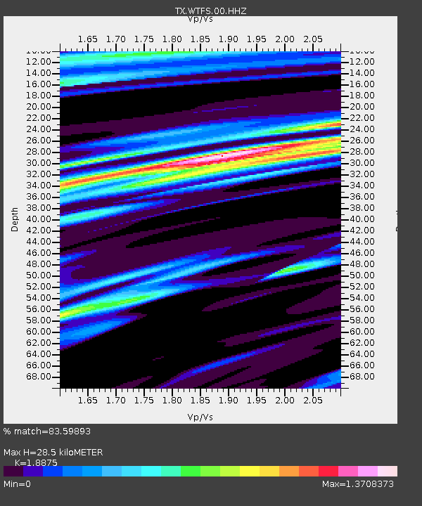
WTFS Witchita Falls - Earthquake Result Viewer
| Earthquake location: |
Svalbard Region |
| Earthquake latitude/longitude: |
78.6/6.0 |
| Earthquake time(UTC): |
2022/07/18 (199) 18:40:32 GMT |
| Earthquake Depth: |
10 km |
| Earthquake Magnitude: |
5.9 Mww |
| Earthquake Catalog/Contributor: |
NEIC PDE/us |
|
| Network: |
TX Texas Seismological Network |
| Station: |
WTFS Witchita Falls |
| Lat/Lon: |
33.77 N/98.46 W |
| Elevation: |
277 m |
|
| Distance: |
59.9 deg |
| Az: |
291.281 deg |
| Baz: |
12.811 deg |
| Ray Param: |
0.061854966 |
| Estimated Moho Depth: |
28.5 km |
| Estimated Crust Vp/Vs: |
1.89 |
| Assumed Crust Vp: |
6.426 km/s |
| Estimated Crust Vs: |
3.405 km/s |
| Estimated Crust Poisson's Ratio: |
0.30 |
|
| Radial Match: |
83.59893 % |
| Radial Bump: |
400 |
| Transverse Match: |
71.556816 % |
| Transverse Bump: |
400 |
| SOD ConfigId: |
28208852 |
| Insert Time: |
2022-08-01 19:12:29.128 +0000 |
| GWidth: |
2.5 |
| Max Bumps: |
400 |
| Tol: |
0.001 |
|

Signal To Noise
| Channel | StoN | STA | LTA |
| TX:WTFS:00:HHZ:20220718T18:50:08.020024Z | 3.5777867 | 5.795599E-7 | 1.619884E-7 |
| TX:WTFS:00:HH1:20220718T18:50:08.020024Z | 0.8637709 | 1.2409254E-7 | 1.4366371E-7 |
| TX:WTFS:00:HH2:20220718T18:50:08.020024Z | 0.9279246 | 1.2995595E-7 | 1.4005012E-7 |
| Arrivals |
| Ps | 4.1 SECOND |
| PpPs | 12 SECOND |
| PsPs/PpSs | 16 SECOND |


