You are here: Home > Network List > GS - US Geological Survey Networks Stations List
> Station DEC05 Apollo Drive Surface Site > Earthquake Result Viewer
DEC05 Apollo Drive Surface Site - Earthquake Result Viewer

| Earthquake location: |
Near Coast Of Venezuela |
| Earthquake latitude/longitude: |
10.9/-62.9 |
| Earthquake time(UTC): |
2018/08/21 (233) 21:31:46 GMT |
| Earthquake Depth: |
154 km |
| Earthquake Magnitude: |
7.3 Mww |
| Earthquake Catalog/Contributor: |
NEIC PDE/us |
|
| Network: |
GS US Geological Survey Networks |
| Station: |
DEC05 Apollo Drive Surface Site |
| Lat/Lon: |
39.87 N/88.87 W |
| Elevation: |
216 m |
|
| Distance: |
37.0 deg |
| Az: |
325.888 deg |
| Baz: |
134.289 deg |
| Ray Param: |
0.075849116 |
| Estimated Moho Depth: |
25.0 km |
| Estimated Crust Vp/Vs: |
1.76 |
| Assumed Crust Vp: |
6.444 km/s |
| Estimated Crust Vs: |
3.656 km/s |
| Estimated Crust Poisson's Ratio: |
0.26 |
|
| Radial Match: |
92.54722 % |
| Radial Bump: |
400 |
| Transverse Match: |
78.89062 % |
| Transverse Bump: |
400 |
| SOD ConfigId: |
2825771 |
| Insert Time: |
2018-09-04 21:45:26.414 +0000 |
| GWidth: |
2.5 |
| Max Bumps: |
400 |
| Tol: |
0.001 |
|
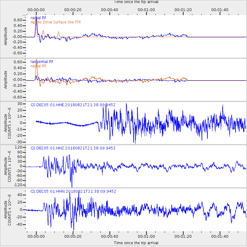
Signal To Noise
| Channel | StoN | STA | LTA |
| GS:DEC05:01:HHZ:20180821T21:38:09.945Z | 71.81297 | 1.7183253E-5 | 2.3927785E-7 |
| GS:DEC05:01:HHN:20180821T21:38:09.945Z | 7.9909587 | 6.024346E-6 | 7.538952E-7 |
| GS:DEC05:01:HHE:20180821T21:38:09.945Z | 2.4819798 | 4.2841616E-6 | 1.7261066E-6 |
| Arrivals |
| Ps | 3.2 SECOND |
| PpPs | 10.0 SECOND |
| PsPs/PpSs | 13 SECOND |


