You are here: Home > Network List > GS - US Geological Survey Networks Stations List
> Station KAN12 Houston Home > Earthquake Result Viewer
KAN12 Houston Home - Earthquake Result Viewer
| Earthquake location: |
Near Coast Of Venezuela |
| Earthquake latitude/longitude: |
10.9/-62.9 |
| Earthquake time(UTC): |
2018/08/21 (233) 21:31:46 GMT |
| Earthquake Depth: |
154 km |
| Earthquake Magnitude: |
7.3 Mww |
| Earthquake Catalog/Contributor: |
NEIC PDE/us |
|
| Network: |
GS US Geological Survey Networks |
| Station: |
KAN12 Houston Home |
| Lat/Lon: |
37.30 N/98.00 W |
| Elevation: |
426 m |
|
| Distance: |
41.1 deg |
| Az: |
315.737 deg |
| Baz: |
120.709 deg |
| Ray Param: |
0.073419504 |
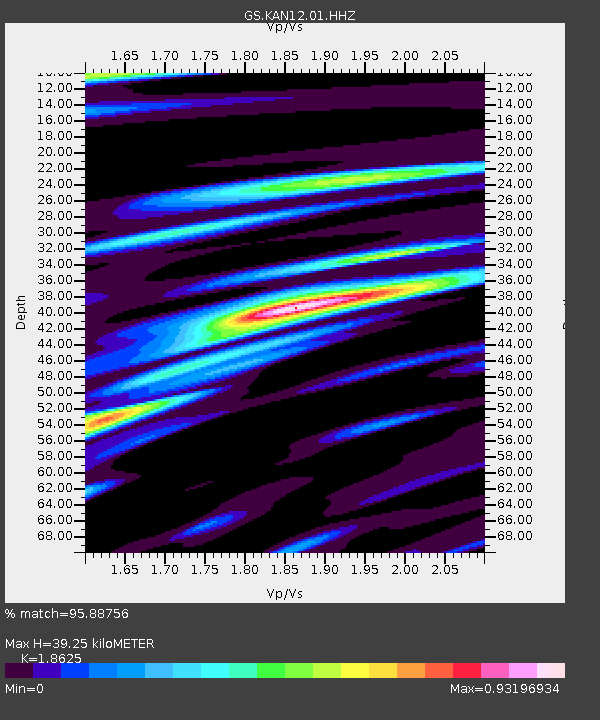
| Estimated Moho Depth: |
39.25 km |
| Estimated Crust Vp/Vs: |
1.86 |
| Assumed Crust Vp: |
6.483 km/s |
| Estimated Crust Vs: |
3.481 km/s |
| Estimated Crust Poisson's Ratio: |
0.30 |
|
| Radial Match: |
95.88756 % |
| Radial Bump: |
352 |
| Transverse Match: |
80.73204 % |
| Transverse Bump: |
400 |
| SOD ConfigId: |
2825771 |
| Insert Time: |
2018-09-04 21:45:43.823 +0000 |
| GWidth: |
2.5 |
| Max Bumps: |
400 |
| Tol: |
0.001 |
|

Signal To Noise
| Channel | StoN | STA | LTA |
| GS:KAN12:01:HHZ:20180821T21:38:44.195Z | 70.87206 | 1.5959602E-5 | 2.2518888E-7 |
| GS:KAN12:01:HHN:20180821T21:38:44.195Z | 16.514673 | 4.0887753E-6 | 2.4758438E-7 |
| GS:KAN12:01:HHE:20180821T21:38:44.195Z | 12.72654 | 5.6969543E-6 | 4.4764363E-7 |
| Arrivals |
| Ps | 5.6 SECOND |
| PpPs | 16 SECOND |
| PsPs/PpSs | 22 SECOND |


