You are here: Home > Network List > XK99 - CDROM (Colorado) Stations List
> Station N16 North 16 > Earthquake Result Viewer
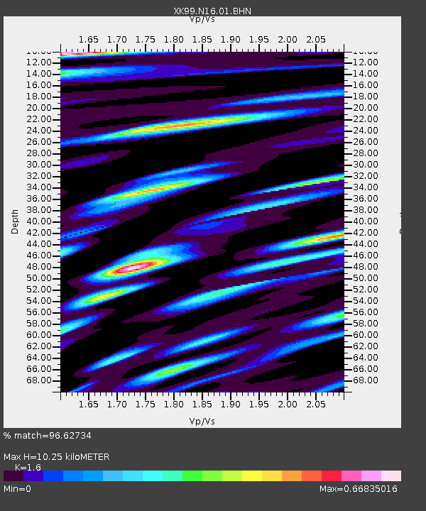
N16 North 16 - Earthquake Result Viewer
| Earthquake location: |
Santiago Del Estero Prov., Arg. |
| Earthquake latitude/longitude: |
-28.3/-63.0 |
| Earthquake time(UTC): |
2000/04/23 (114) 09:27:23 GMT |
| Earthquake Depth: |
608 km |
| Earthquake Magnitude: |
6.6 MB, 7.0 MW, 7.0 MW |
| Earthquake Catalog/Contributor: |
WHDF/NEIC |
|
| Network: |
XK CDROM (Colorado) |
| Station: |
N16 North 16 |
| Lat/Lon: |
40.92 N/106.99 W |
| Elevation: |
2380 m |
|
| Distance: |
80.1 deg |
| Az: |
327.696 deg |
| Baz: |
141.548 deg |
| Ray Param: |
0.046652663 |
| Estimated Moho Depth: |
10.25 km |
| Estimated Crust Vp/Vs: |
1.60 |
| Assumed Crust Vp: |
6.159 km/s |
| Estimated Crust Vs: |
3.849 km/s |
| Estimated Crust Poisson's Ratio: |
0.18 |
|
| Radial Match: |
96.62734 % |
| Radial Bump: |
400 |
| Transverse Match: |
88.97733 % |
| Transverse Bump: |
400 |
| SOD ConfigId: |
287362 |
| Insert Time: |
2010-03-09 22:42:10.312 +0000 |
| GWidth: |
2.5 |
| Max Bumps: |
400 |
| Tol: |
0.001 |
|

Signal To Noise
| Channel | StoN | STA | LTA |
| XK:N16:01:BHN:20000423T09:37:59.882012Z | 13.885276 | 1.0565092E-6 | 7.608845E-8 |
| XK:N16:01:BHE:20000423T09:37:59.882012Z | 9.697252 | 1.3193444E-6 | 1.3605342E-7 |
| XK:N16:01:BHZ:20000423T09:37:59.882012Z | 68.34554 | 6.401042E-6 | 9.365705E-8 |
| Arrivals |
| Ps | 1.0 SECOND |
| PpPs | 4.2 SECOND |
| PsPs/PpSs | 5.2 SECOND |


