You are here: Home > Network List > GS - US Geological Survey Networks Stations List
> Station NE02 NE02 Southeast of Arnold, NE > Earthquake Result Viewer
NE02 NE02 Southeast of Arnold, NE - Earthquake Result Viewer
| Earthquake location: |
Near Coast Of Venezuela |
| Earthquake latitude/longitude: |
10.9/-62.9 |
| Earthquake time(UTC): |
2018/08/21 (233) 21:31:46 GMT |
| Earthquake Depth: |
154 km |
| Earthquake Magnitude: |
7.3 Mww |
| Earthquake Catalog/Contributor: |
NEIC PDE/us |
|
| Network: |
GS US Geological Survey Networks |
| Station: |
NE02 NE02 Southeast of Arnold, NE |
| Lat/Lon: |
41.35 N/100.09 W |
| Elevation: |
817 m |
|
| Distance: |
44.6 deg |
| Az: |
319.571 deg |
| Baz: |
122.2 deg |
| Ray Param: |
0.07124881 |
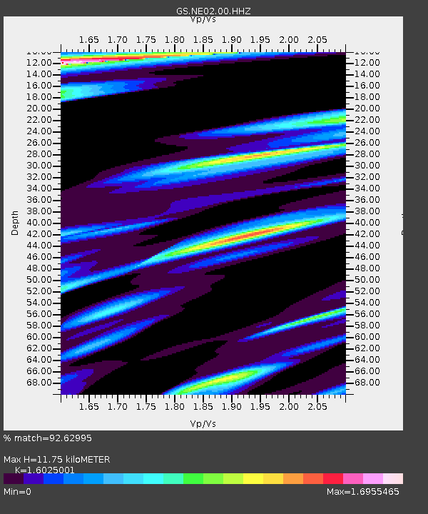
| Estimated Moho Depth: |
11.75 km |
| Estimated Crust Vp/Vs: |
1.60 |
| Assumed Crust Vp: |
6.483 km/s |
| Estimated Crust Vs: |
4.045 km/s |
| Estimated Crust Poisson's Ratio: |
0.18 |
|
| Radial Match: |
92.62995 % |
| Radial Bump: |
301 |
| Transverse Match: |
81.00867 % |
| Transverse Bump: |
400 |
| SOD ConfigId: |
2825771 |
| Insert Time: |
2018-09-04 21:46:06.408 +0000 |
| GWidth: |
2.5 |
| Max Bumps: |
400 |
| Tol: |
0.001 |
|

Signal To Noise
| Channel | StoN | STA | LTA |
| GS:NE02:00:HHZ:20180821T21:39:12.309014Z | 82.66779 | 1.5360702E-5 | 1.8581241E-7 |
| GS:NE02:00:HH1:20180821T21:39:12.309014Z | 6.6009517 | 3.3404162E-6 | 5.060507E-7 |
| GS:NE02:00:HH2:20180821T21:39:12.309014Z | 15.590166 | 5.9170334E-6 | 3.7953626E-7 |
| Arrivals |
| Ps | 1.2 SECOND |
| PpPs | 4.4 SECOND |
| PsPs/PpSs | 5.6 SECOND |


