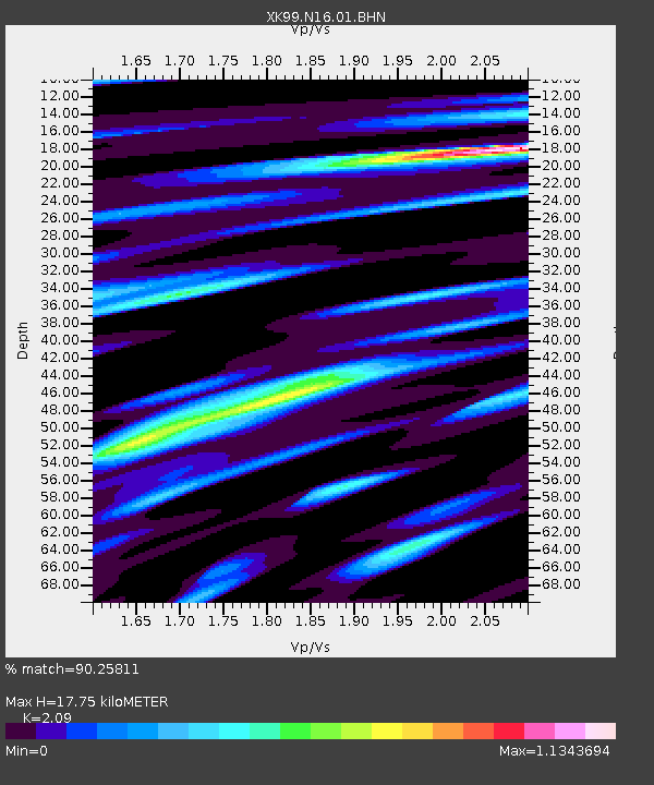
N16 North 16 - Earthquake Result Viewer

Earthquake location: Andreanof Islands, Aleutian Is.
Earthquake latitude/longitude: 51.4/-178.1
Earthquake time(UTC): 2000/04/21 (112) 04:35:17 GMT
Earthquake Depth: 33 km
Earthquake Magnitude: 6.0 MB, 5.7 MS, 6.2 ML, 6.0 MW
Earthquake Catalog/Contributor: WHDF/NEIC
Network: XK CDROM (Colorado)
Station: N16 North 16
Lat/Lon: 40.92 N/106.99 W
Elevation: 2380 m
Distance: 48.5 deg
Az: 73.115 deg
Baz: 307.749 deg
Ray Param: 0.06922902
Estimated Moho Depth: 17.75 km
Estimated Crust Vp/Vs: 2.09
Assumed Crust Vp: 6.159 km/s
Estimated Crust Vs: 2.947 km/s
Estimated Crust Poisson's Ratio: 0.35
Radial Match: 90.25811 %
Radial Bump: 400
Transverse Match: 86.24538 %
Transverse Bump: 400
SOD ConfigId: 287362
Insert Time: 2010-03-09 22:42:11.617 +0000
GWidth: 2.5
Max Bumps: 400
Tol: 0.001

Signal To Noise

ChannelStoNSTALTA
XK:N16:01:BHN:20000421T04:43:27.015012Z4.0365943.1851872E-77.8907796E-8
XK:N16:01:BHE:20000421T04:43:27.015012Z4.9587373.814676E-77.692838E-8
XK:N16:01:BHZ:20000421T04:43:27.015012Z10.7287979.3516104E-78.716365E-8
Arrivals
Ps3.3 SECOND
PpPs8.5 SECOND
PsPs/PpSs12 SECOND