You are here: Home > Network List > G - GEOSCOPE Stations List
> Station IVI Ivittuut, Greenland > Earthquake Result Viewer
IVI Ivittuut, Greenland - Earthquake Result Viewer
| Earthquake location: |
Myanmar-China Border Region |
| Earthquake latitude/longitude: |
21.2/99.9 |
| Earthquake time(UTC): |
2022/07/21 (202) 17:07:25 GMT |
| Earthquake Depth: |
5.0 km |
| Earthquake Magnitude: |
5.9 mww |
| Earthquake Catalog/Contributor: |
NEIC PDE/us |
|
| Network: |
G GEOSCOPE |
| Station: |
IVI Ivittuut, Greenland |
| Lat/Lon: |
61.21 N/48.17 W |
| Elevation: |
15 m |
|
| Distance: |
94.0 deg |
| Az: |
345.12 deg |
| Baz: |
29.677 deg |
| Ray Param: |
0.041150104 |
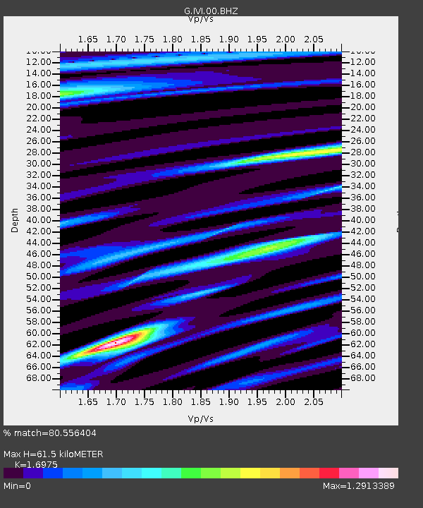
| Estimated Moho Depth: |
61.5 km |
| Estimated Crust Vp/Vs: |
1.70 |
| Assumed Crust Vp: |
6.472 km/s |
| Estimated Crust Vs: |
3.813 km/s |
| Estimated Crust Poisson's Ratio: |
0.23 |
|
| Radial Match: |
80.556404 % |
| Radial Bump: |
400 |
| Transverse Match: |
71.112495 % |
| Transverse Bump: |
400 |
| SOD ConfigId: |
28764291 |
| Insert Time: |
2022-08-04 17:15:33.473 +0000 |
| GWidth: |
2.5 |
| Max Bumps: |
400 |
| Tol: |
0.001 |
|
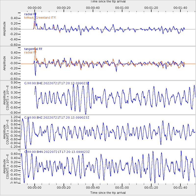
Signal To Noise
| Channel | StoN | STA | LTA |
| G:IVI:00:BHZ:20220721T17:20:13.099023Z | 0.5393223 | 3.1587342E-7 | 5.8568577E-7 |
| G:IVI:00:BHN:20220721T17:20:13.099023Z | 0.8810539 | 2.849783E-7 | 3.234516E-7 |
| G:IVI:00:BHE:20220721T17:20:13.099023Z | 1.9345459 | 5.4346424E-7 | 2.80926E-7 |
| Arrivals |
| Ps | 6.8 SECOND |
| PpPs | 25 SECOND |
| PsPs/PpSs | 32 SECOND |


