You are here: Home > Network List > XK99 - CDROM (Colorado) Stations List
> Station N16 North 16 > Earthquake Result Viewer
N16 North 16 - Earthquake Result Viewer
| Earthquake location: |
Vanuatu Islands Region |
| Earthquake latitude/longitude: |
-19.5/173.8 |
| Earthquake time(UTC): |
2000/02/25 (056) 01:43:58 GMT |
| Earthquake Depth: |
33 km |
| Earthquake Magnitude: |
6.1 MB, 7.1 MS, 7.1 MW, 7.0 MW |
| Earthquake Catalog/Contributor: |
WHDF/NEIC |
|
| Network: |
XK CDROM (Colorado) |
| Station: |
N16 North 16 |
| Lat/Lon: |
40.92 N/106.99 W |
| Elevation: |
2380 m |
|
| Distance: |
94.8 deg |
| Az: |
48.32 deg |
| Baz: |
248.379 deg |
| Ray Param: |
0.04095051 |
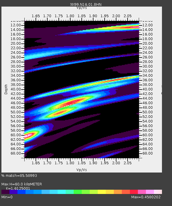
| Estimated Moho Depth: |
60.0 km |
| Estimated Crust Vp/Vs: |
1.61 |
| Assumed Crust Vp: |
6.159 km/s |
| Estimated Crust Vs: |
3.819 km/s |
| Estimated Crust Poisson's Ratio: |
0.19 |
|
| Radial Match: |
85.58993 % |
| Radial Bump: |
354 |
| Transverse Match: |
81.828064 % |
| Transverse Bump: |
400 |
| SOD ConfigId: |
3744 |
| Insert Time: |
2010-03-09 22:42:20.343 +0000 |
| GWidth: |
2.5 |
| Max Bumps: |
400 |
| Tol: |
0.001 |
|

Signal To Noise
| Channel | StoN | STA | LTA |
| XK:N16:01:BHN:20000225T01:56:45.397019Z | 0.872671 | 1.3156593E-7 | 1.5076233E-7 |
| XK:N16:01:BHE:20000225T01:56:45.397019Z | 1.8973393 | 2.0956766E-7 | 1.1045344E-7 |
| XK:N16:01:BHZ:20000225T01:56:45.397019Z | 1.325118 | 2.2400344E-7 | 1.6904416E-7 |
| Arrivals |
| Ps | 6.1 SECOND |
| PpPs | 25 SECOND |
| PsPs/PpSs | 31 SECOND |


