You are here: Home > Network List > NE - New England Seismic Network Stations List
> Station VT1 Waterbury, VT, USA > Earthquake Result Viewer
VT1 Waterbury, VT, USA - Earthquake Result Viewer
| Earthquake location: |
Near Coast Of Venezuela |
| Earthquake latitude/longitude: |
10.9/-62.9 |
| Earthquake time(UTC): |
2018/08/21 (233) 21:31:46 GMT |
| Earthquake Depth: |
154 km |
| Earthquake Magnitude: |
7.3 Mww |
| Earthquake Catalog/Contributor: |
NEIC PDE/us |
|
| Network: |
NE New England Seismic Network |
| Station: |
VT1 Waterbury, VT, USA |
| Lat/Lon: |
44.32 N/72.75 W |
| Elevation: |
149 m |
|
| Distance: |
34.4 deg |
| Az: |
347.429 deg |
| Baz: |
162.67 deg |
| Ray Param: |
0.07722871 |
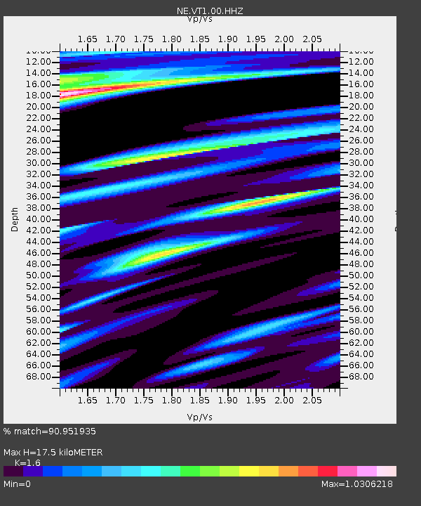
| Estimated Moho Depth: |
17.5 km |
| Estimated Crust Vp/Vs: |
1.60 |
| Assumed Crust Vp: |
6.419 km/s |
| Estimated Crust Vs: |
4.012 km/s |
| Estimated Crust Poisson's Ratio: |
0.18 |
|
| Radial Match: |
90.951935 % |
| Radial Bump: |
400 |
| Transverse Match: |
88.22272 % |
| Transverse Bump: |
400 |
| SOD ConfigId: |
2825771 |
| Insert Time: |
2018-09-04 21:47:46.579 +0000 |
| GWidth: |
2.5 |
| Max Bumps: |
400 |
| Tol: |
0.001 |
|

Signal To Noise
| Channel | StoN | STA | LTA |
| NE:VT1:00:HHZ:20180821T21:37:48.334008Z | 25.092665 | 6.8614245E-6 | 2.7344345E-7 |
| NE:VT1:00:HH1:20180821T21:37:48.334008Z | 10.221412 | 3.5862797E-6 | 3.5085952E-7 |
| NE:VT1:00:HH2:20180821T21:37:48.334008Z | 1.2554401 | 3.7742865E-7 | 3.0063455E-7 |
| Arrivals |
| Ps | 1.8 SECOND |
| PpPs | 6.5 SECOND |
| PsPs/PpSs | 8.3 SECOND |


