You are here: Home > Network List > NM - Cooperative New Madrid Seismic Network Stations List
> Station CGM3 Cape Girardeau, MO > Earthquake Result Viewer
CGM3 Cape Girardeau, MO - Earthquake Result Viewer
| Earthquake location: |
Near Coast Of Venezuela |
| Earthquake latitude/longitude: |
10.9/-62.9 |
| Earthquake time(UTC): |
2018/08/21 (233) 21:31:46 GMT |
| Earthquake Depth: |
154 km |
| Earthquake Magnitude: |
7.3 Mww |
| Earthquake Catalog/Contributor: |
NEIC PDE/us |
|
| Network: |
NM Cooperative New Madrid Seismic Network |
| Station: |
CGM3 Cape Girardeau, MO |
| Lat/Lon: |
37.30 N/89.66 W |
| Elevation: |
148 m |
|
| Distance: |
35.7 deg |
| Az: |
321.981 deg |
| Baz: |
130.649 deg |
| Ray Param: |
0.07654933 |
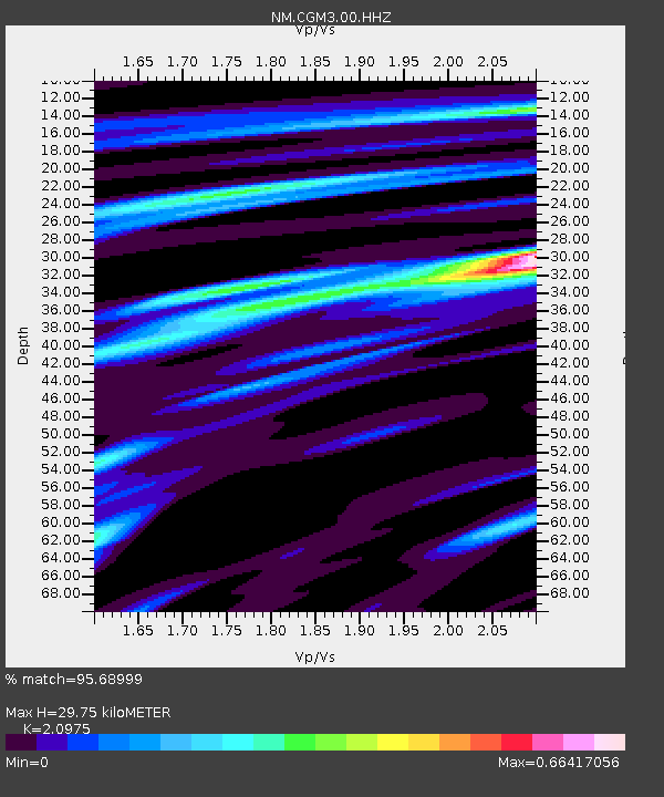
| Estimated Moho Depth: |
29.75 km |
| Estimated Crust Vp/Vs: |
2.10 |
| Assumed Crust Vp: |
6.444 km/s |
| Estimated Crust Vs: |
3.072 km/s |
| Estimated Crust Poisson's Ratio: |
0.35 |
|
| Radial Match: |
95.68999 % |
| Radial Bump: |
253 |
| Transverse Match: |
87.72546 % |
| Transverse Bump: |
400 |
| SOD ConfigId: |
2825771 |
| Insert Time: |
2018-09-04 21:47:54.494 +0000 |
| GWidth: |
2.5 |
| Max Bumps: |
400 |
| Tol: |
0.001 |
|

Signal To Noise
| Channel | StoN | STA | LTA |
| NM:CGM3:00:HHZ:20180821T21:37:59.12899Z | 79.88954 | 1.0417155E-5 | 1.3039447E-7 |
| NM:CGM3:00:HHN:20180821T21:37:59.12899Z | 41.605858 | 5.0642625E-6 | 1.2171994E-7 |
| NM:CGM3:00:HHE:20180821T21:37:59.12899Z | 47.61882 | 4.114348E-6 | 8.640171E-8 |
| Arrivals |
| Ps | 5.4 SECOND |
| PpPs | 13 SECOND |
| PsPs/PpSs | 19 SECOND |


