You are here: Home > Network List > NM - Cooperative New Madrid Seismic Network Stations List
> Station LNXT Lenox,TN > Earthquake Result Viewer
LNXT Lenox,TN - Earthquake Result Viewer
| Earthquake location: |
Near Coast Of Venezuela |
| Earthquake latitude/longitude: |
10.9/-62.9 |
| Earthquake time(UTC): |
2018/08/21 (233) 21:31:46 GMT |
| Earthquake Depth: |
154 km |
| Earthquake Magnitude: |
7.3 Mww |
| Earthquake Catalog/Contributor: |
NEIC PDE/us |
|
| Network: |
NM Cooperative New Madrid Seismic Network |
| Station: |
LNXT Lenox,TN |
| Lat/Lon: |
36.10 N/89.49 W |
| Elevation: |
144 m |
|
| Distance: |
34.8 deg |
| Az: |
320.549 deg |
| Baz: |
129.578 deg |
| Ray Param: |
0.07701922 |
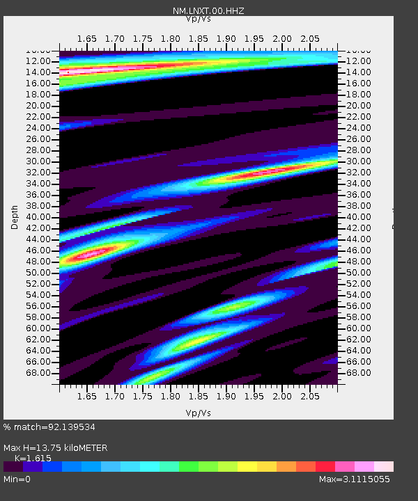
| Estimated Moho Depth: |
13.75 km |
| Estimated Crust Vp/Vs: |
1.62 |
| Assumed Crust Vp: |
6.444 km/s |
| Estimated Crust Vs: |
3.99 km/s |
| Estimated Crust Poisson's Ratio: |
0.19 |
|
| Radial Match: |
92.139534 % |
| Radial Bump: |
356 |
| Transverse Match: |
63.690113 % |
| Transverse Bump: |
400 |
| SOD ConfigId: |
2825771 |
| Insert Time: |
2018-09-04 21:48:13.185 +0000 |
| GWidth: |
2.5 |
| Max Bumps: |
400 |
| Tol: |
0.001 |
|

Signal To Noise
| Channel | StoN | STA | LTA |
| NM:LNXT:00:HHZ:20180821T21:37:51.695Z | 65.74047 | 1.492278E-5 | 2.2699534E-7 |
| NM:LNXT:00:HHN:20180821T21:37:51.695Z | 4.660513 | 5.254433E-6 | 1.1274366E-6 |
| NM:LNXT:00:HHE:20180821T21:37:51.695Z | 8.585999 | 6.682072E-6 | 7.782522E-7 |
| Arrivals |
| Ps | 1.4 SECOND |
| PpPs | 5.1 SECOND |
| PsPs/PpSs | 6.6 SECOND |


