You are here: Home > Network List > AG - Arkansas Seismic Network Stations List
> Station HHAR Hobbs,AR > Earthquake Result Viewer
HHAR Hobbs,AR - Earthquake Result Viewer
| Earthquake location: |
Colombia-Ecuador Border Region |
| Earthquake latitude/longitude: |
0.7/-77.8 |
| Earthquake time(UTC): |
2022/07/25 (206) 13:33:28 GMT |
| Earthquake Depth: |
4.0 km |
| Earthquake Magnitude: |
5.7 mww |
| Earthquake Catalog/Contributor: |
NEIC PDE/us |
|
| Network: |
AG Arkansas Seismic Network |
| Station: |
HHAR Hobbs,AR |
| Lat/Lon: |
36.28 N/93.94 W |
| Elevation: |
421 m |
|
| Distance: |
38.4 deg |
| Az: |
338.853 deg |
| Baz: |
153.483 deg |
| Ray Param: |
0.075598255 |
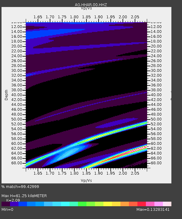
| Estimated Moho Depth: |
61.25 km |
| Estimated Crust Vp/Vs: |
2.09 |
| Assumed Crust Vp: |
6.53 km/s |
| Estimated Crust Vs: |
3.125 km/s |
| Estimated Crust Poisson's Ratio: |
0.35 |
|
| Radial Match: |
99.42999 % |
| Radial Bump: |
65 |
| Transverse Match: |
88.85331 % |
| Transverse Bump: |
312 |
| SOD ConfigId: |
28764291 |
| Insert Time: |
2022-08-08 13:35:39.607 +0000 |
| GWidth: |
2.5 |
| Max Bumps: |
400 |
| Tol: |
0.001 |
|

Signal To Noise
| Channel | StoN | STA | LTA |
| AG:HHAR:00:HHZ:20220725T13:40:20.820005Z | 2.0178108 | 3.2641744E-6 | 1.617681E-6 |
| AG:HHAR:00:HHN:20220725T13:40:20.820005Z | 2.0986621 | 4.024379E-6 | 1.9175927E-6 |
| AG:HHAR:00:HHE:20220725T13:40:20.820005Z | 1.939644 | 2.3947161E-6 | 1.2346163E-6 |
| Arrivals |
| Ps | 11 SECOND |
| PpPs | 27 SECOND |
| PsPs/PpSs | 38 SECOND |


