You are here: Home > Network List > XK99 - CDROM (Colorado) Stations List
> Station S02 South 02 > Earthquake Result Viewer
S02 South 02 - Earthquake Result Viewer
| Earthquake location: |
Kuril Islands |
| Earthquake latitude/longitude: |
49.9/156.3 |
| Earthquake time(UTC): |
1999/08/06 (218) 00:32:41 GMT |
| Earthquake Depth: |
58 km |
| Earthquake Magnitude: |
5.5 MB, 5.5 MS, 5.9 MW, 5.8 MW |
| Earthquake Catalog/Contributor: |
WHDF/NEIC |
|
| Network: |
XK CDROM (Colorado) |
| Station: |
S02 South 02 |
| Lat/Lon: |
37.15 N/105.45 W |
| Elevation: |
2567 m |
|
| Distance: |
67.4 deg |
| Az: |
58.925 deg |
| Baz: |
316.154 deg |
| Ray Param: |
0.05686443 |
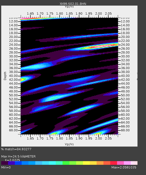
| Estimated Moho Depth: |
24.5 km |
| Estimated Crust Vp/Vs: |
2.02 |
| Assumed Crust Vp: |
6.316 km/s |
| Estimated Crust Vs: |
3.123 km/s |
| Estimated Crust Poisson's Ratio: |
0.34 |
|
| Radial Match: |
84.93277 % |
| Radial Bump: |
400 |
| Transverse Match: |
79.34874 % |
| Transverse Bump: |
400 |
| SOD ConfigId: |
287362 |
| Insert Time: |
2010-03-09 22:44:45.518 +0000 |
| GWidth: |
2.5 |
| Max Bumps: |
400 |
| Tol: |
0.001 |
|

Signal To Noise
| Channel | StoN | STA | LTA |
| XK:S02:01:BHN:19990806T00:43:00.160002Z | 1.1270553 | 1.5737942E-7 | 1.396377E-7 |
| XK:S02:01:BHE:19990806T00:43:00.160002Z | 0.97010994 | 1.0083074E-7 | 1.0393744E-7 |
| XK:S02:01:BHZ:19990806T00:43:00.160002Z | 3.7459106 | 3.6302703E-7 | 9.691289E-8 |
| Arrivals |
| Ps | 4.1 SECOND |
| PpPs | 11 SECOND |
| PsPs/PpSs | 15 SECOND |


