You are here: Home > Network List > IW - Intermountain West Stations List
> Station MOOW Moose Ponds, Wyoming, USA > Earthquake Result Viewer
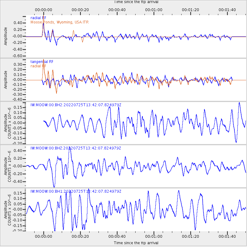
MOOW Moose Ponds, Wyoming, USA - Earthquake Result Viewer
*The percent match for this event was below the threshold and hence no stack was calculated.
| Earthquake location: |
Colombia-Ecuador Border Region |
| Earthquake latitude/longitude: |
0.7/-77.8 |
| Earthquake time(UTC): |
2022/07/25 (206) 13:33:28 GMT |
| Earthquake Depth: |
4.0 km |
| Earthquake Magnitude: |
5.7 mww |
| Earthquake Catalog/Contributor: |
NEIC PDE/us |
|
| Network: |
IW Intermountain West |
| Station: |
MOOW Moose Ponds, Wyoming, USA |
| Lat/Lon: |
43.75 N/110.74 W |
| Elevation: |
2128 m |
|
| Distance: |
51.9 deg |
| Az: |
329.984 deg |
| Baz: |
136.352 deg |
| Ray Param: |
$rayparam |
*The percent match for this event was below the threshold and hence was not used in the summary stack. |
|
| Radial Match: |
75.84857 % |
| Radial Bump: |
400 |
| Transverse Match: |
56.782234 % |
| Transverse Bump: |
400 |
| SOD ConfigId: |
28764291 |
| Insert Time: |
2022-08-08 13:49:36.040 +0000 |
| GWidth: |
2.5 |
| Max Bumps: |
400 |
| Tol: |
0.001 |
|
Signal To Noise
| Channel | StoN | STA | LTA |
| IW:MOOW:00:BHZ:20220725T13:42:07.824979Z | 2.8947253 | 1.01285565E-7 | 3.4989696E-8 |
| IW:MOOW:00:BH1:20220725T13:42:07.824979Z | 1.0696192 | 4.1277715E-8 | 3.859104E-8 |
| IW:MOOW:00:BH2:20220725T13:42:07.824979Z | 1.7139438 | 7.112233E-8 | 4.1496303E-8 |
| Arrivals |
| Ps | |
| PpPs | |
| PsPs/PpSs | |


