You are here: Home > Network List > N4 - Central and EAstern US Network Stations List
> Station N47A Urbana, IN, USA > Earthquake Result Viewer
N47A Urbana, IN, USA - Earthquake Result Viewer
| Earthquake location: |
Colombia-Ecuador Border Region |
| Earthquake latitude/longitude: |
0.7/-77.8 |
| Earthquake time(UTC): |
2022/07/25 (206) 13:33:28 GMT |
| Earthquake Depth: |
4.0 km |
| Earthquake Magnitude: |
5.7 mww |
| Earthquake Catalog/Contributor: |
NEIC PDE/us |
|
| Network: |
N4 Central and EAstern US Network |
| Station: |
N47A Urbana, IN, USA |
| Lat/Lon: |
40.88 N/85.69 W |
| Elevation: |
252 m |
|
| Distance: |
40.6 deg |
| Az: |
350.824 deg |
| Baz: |
167.861 deg |
| Ray Param: |
0.074297875 |
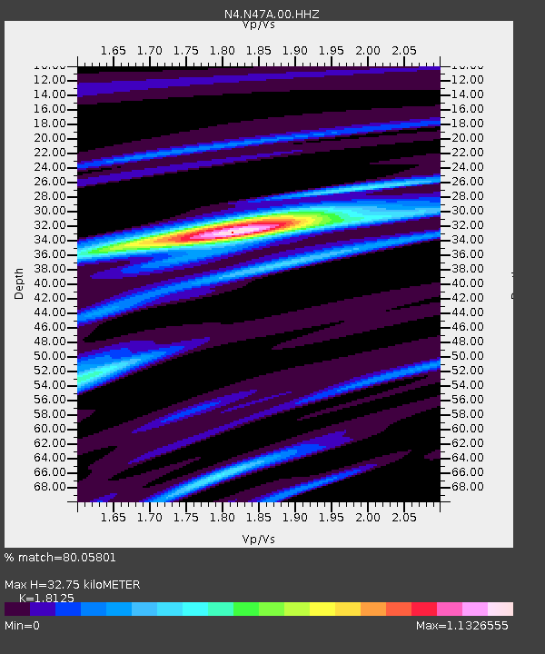
| Estimated Moho Depth: |
32.75 km |
| Estimated Crust Vp/Vs: |
1.81 |
| Assumed Crust Vp: |
6.498 km/s |
| Estimated Crust Vs: |
3.585 km/s |
| Estimated Crust Poisson's Ratio: |
0.28 |
|
| Radial Match: |
80.05801 % |
| Radial Bump: |
385 |
| Transverse Match: |
51.644028 % |
| Transverse Bump: |
400 |
| SOD ConfigId: |
28764291 |
| Insert Time: |
2022-08-08 13:51:24.452 +0000 |
| GWidth: |
2.5 |
| Max Bumps: |
400 |
| Tol: |
0.001 |
|

Signal To Noise
| Channel | StoN | STA | LTA |
| N4:N47A:00:HHZ:20220725T13:40:39.089994Z | 4.878875 | 4.4506075E-7 | 9.1222006E-8 |
| N4:N47A:00:HH1:20220725T13:40:39.089994Z | 3.4446442 | 2.9221755E-7 | 8.4832436E-8 |
| N4:N47A:00:HH2:20220725T13:40:39.089994Z | 1.1923555 | 8.314906E-8 | 6.973512E-8 |
| Arrivals |
| Ps | 4.4 SECOND |
| PpPs | 13 SECOND |
| PsPs/PpSs | 18 SECOND |


