You are here: Home > Network List > O2 - Oklahoma Consolidated Temporary Seismic Networks Stations List
> Station DRIP Dripping spring state park, Oklahoma, USA > Earthquake Result Viewer
DRIP Dripping spring state park, Oklahoma, USA - Earthquake Result Viewer
| Earthquake location: |
Colombia-Ecuador Border Region |
| Earthquake latitude/longitude: |
0.7/-77.8 |
| Earthquake time(UTC): |
2022/07/25 (206) 13:33:28 GMT |
| Earthquake Depth: |
4.0 km |
| Earthquake Magnitude: |
5.7 mww |
| Earthquake Catalog/Contributor: |
NEIC PDE/us |
|
| Network: |
O2 Oklahoma Consolidated Temporary Seismic Networks |
| Station: |
DRIP Dripping spring state park, Oklahoma, USA |
| Lat/Lon: |
35.61 N/96.07 W |
| Elevation: |
243 m |
|
| Distance: |
38.7 deg |
| Az: |
335.909 deg |
| Baz: |
149.939 deg |
| Ray Param: |
0.075468004 |
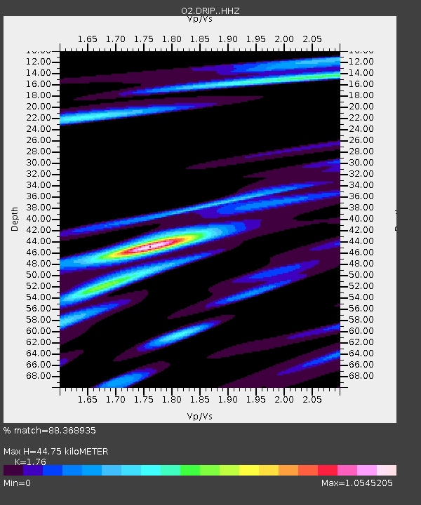
| Estimated Moho Depth: |
44.75 km |
| Estimated Crust Vp/Vs: |
1.76 |
| Assumed Crust Vp: |
6.426 km/s |
| Estimated Crust Vs: |
3.651 km/s |
| Estimated Crust Poisson's Ratio: |
0.26 |
|
| Radial Match: |
88.368935 % |
| Radial Bump: |
293 |
| Transverse Match: |
62.81845 % |
| Transverse Bump: |
400 |
| SOD ConfigId: |
28764291 |
| Insert Time: |
2022-08-08 13:54:14.104 +0000 |
| GWidth: |
2.5 |
| Max Bumps: |
400 |
| Tol: |
0.001 |
|

Signal To Noise
| Channel | StoN | STA | LTA |
| O2:DRIP: :HHZ:20220725T13:40:22.744992Z | 3.5287836 | 4.5851735E-7 | 1.2993637E-7 |
| O2:DRIP: :HHN:20220725T13:40:22.744992Z | 3.318706 | 2.4832173E-7 | 7.482486E-8 |
| O2:DRIP: :HHE:20220725T13:40:22.744992Z | 2.204318 | 1.3050084E-7 | 5.920236E-8 |
| Arrivals |
| Ps | 5.7 SECOND |
| PpPs | 18 SECOND |
| PsPs/PpSs | 24 SECOND |


