You are here: Home > Network List > TX - Texas Seismological Network Stations List
> Station PB10 Southeast of Toyah > Earthquake Result Viewer
PB10 Southeast of Toyah - Earthquake Result Viewer
| Earthquake location: |
Colombia-Ecuador Border Region |
| Earthquake latitude/longitude: |
0.7/-77.8 |
| Earthquake time(UTC): |
2022/07/25 (206) 13:33:28 GMT |
| Earthquake Depth: |
4.0 km |
| Earthquake Magnitude: |
5.7 mww |
| Earthquake Catalog/Contributor: |
NEIC PDE/us |
|
| Network: |
TX Texas Seismological Network |
| Station: |
PB10 Southeast of Toyah |
| Lat/Lon: |
31.28 N/103.75 W |
| Elevation: |
858 m |
|
| Distance: |
39.1 deg |
| Az: |
323.584 deg |
| Baz: |
136.105 deg |
| Ray Param: |
0.07521611 |
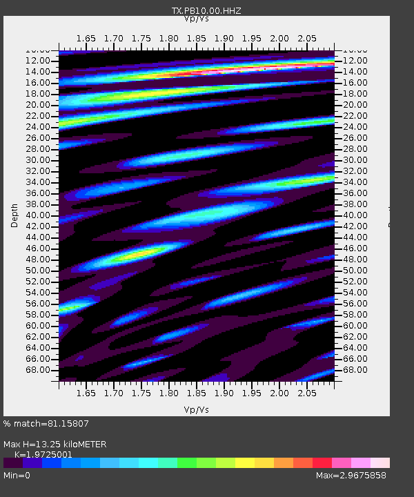
| Estimated Moho Depth: |
13.25 km |
| Estimated Crust Vp/Vs: |
1.97 |
| Assumed Crust Vp: |
6.121 km/s |
| Estimated Crust Vs: |
3.103 km/s |
| Estimated Crust Poisson's Ratio: |
0.33 |
|
| Radial Match: |
81.15807 % |
| Radial Bump: |
400 |
| Transverse Match: |
65.65325 % |
| Transverse Bump: |
400 |
| SOD ConfigId: |
28764291 |
| Insert Time: |
2022-08-08 13:59:10.766 +0000 |
| GWidth: |
2.5 |
| Max Bumps: |
400 |
| Tol: |
0.001 |
|

Signal To Noise
| Channel | StoN | STA | LTA |
| TX:PB10:00:HHZ:20220725T13:40:26.309995Z | 2.8541934 | 2.5215928E-7 | 8.834695E-8 |
| TX:PB10:00:HH1:20220725T13:40:26.309995Z | 1.6454202 | 1.5624742E-7 | 9.495898E-8 |
| TX:PB10:00:HH2:20220725T13:40:26.309995Z | 0.7978724 | 1.0711914E-7 | 1.3425597E-7 |
| Arrivals |
| Ps | 2.2 SECOND |
| PpPs | 6.1 SECOND |
| PsPs/PpSs | 8.3 SECOND |


