You are here: Home > Network List > TX - Texas Seismological Network Stations List
> Station PB33 CR 111 > Earthquake Result Viewer
PB33 CR 111 - Earthquake Result Viewer
| Earthquake location: |
Colombia-Ecuador Border Region |
| Earthquake latitude/longitude: |
0.7/-77.8 |
| Earthquake time(UTC): |
2022/07/25 (206) 13:33:28 GMT |
| Earthquake Depth: |
4.0 km |
| Earthquake Magnitude: |
5.7 mww |
| Earthquake Catalog/Contributor: |
NEIC PDE/us |
|
| Network: |
TX Texas Seismological Network |
| Station: |
PB33 CR 111 |
| Lat/Lon: |
31.53 N/104.05 W |
| Elevation: |
1006 m |
|
| Distance: |
39.5 deg |
| Az: |
323.568 deg |
| Baz: |
135.938 deg |
| Ray Param: |
0.07499704 |
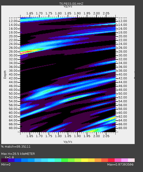
| Estimated Moho Depth: |
28.5 km |
| Estimated Crust Vp/Vs: |
1.60 |
| Assumed Crust Vp: |
6.361 km/s |
| Estimated Crust Vs: |
3.975 km/s |
| Estimated Crust Poisson's Ratio: |
0.18 |
|
| Radial Match: |
89.35111 % |
| Radial Bump: |
400 |
| Transverse Match: |
74.0844 % |
| Transverse Bump: |
400 |
| SOD ConfigId: |
28764291 |
| Insert Time: |
2022-08-08 13:59:23.993 +0000 |
| GWidth: |
2.5 |
| Max Bumps: |
400 |
| Tol: |
0.001 |
|

Signal To Noise
| Channel | StoN | STA | LTA |
| TX:PB33:00:HHZ:20220725T13:40:29.295011Z | 4.087194 | 2.1263164E-8 | 5.2023865E-9 |
| TX:PB33:00:HH1:20220725T13:40:29.295011Z | 2.3817613 | 1.3890056E-8 | 5.8318417E-9 |
| TX:PB33:00:HH2:20220725T13:40:29.295011Z | 1.7365696 | 1.0169221E-8 | 5.855925E-9 |
| Arrivals |
| Ps | 2.9 SECOND |
| PpPs | 11 SECOND |
| PsPs/PpSs | 14 SECOND |


