You are here: Home > Network List > TX - Texas Seismological Network Stations List
> Station SAND Sanderson > Earthquake Result Viewer
SAND Sanderson - Earthquake Result Viewer
| Earthquake location: |
Colombia-Ecuador Border Region |
| Earthquake latitude/longitude: |
0.7/-77.8 |
| Earthquake time(UTC): |
2022/07/25 (206) 13:33:28 GMT |
| Earthquake Depth: |
4.0 km |
| Earthquake Magnitude: |
5.7 mww |
| Earthquake Catalog/Contributor: |
NEIC PDE/us |
|
| Network: |
TX Texas Seismological Network |
| Station: |
SAND Sanderson |
| Lat/Lon: |
29.95 N/102.12 W |
| Elevation: |
689 m |
|
| Distance: |
37.2 deg |
| Az: |
323.765 deg |
| Baz: |
137.074 deg |
| Ray Param: |
0.076313764 |
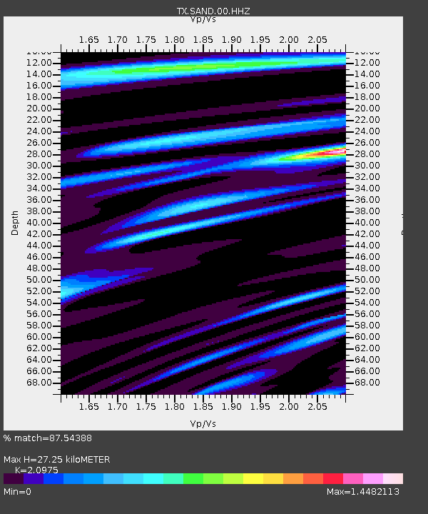
| Estimated Moho Depth: |
27.25 km |
| Estimated Crust Vp/Vs: |
2.10 |
| Assumed Crust Vp: |
6.419 km/s |
| Estimated Crust Vs: |
3.06 km/s |
| Estimated Crust Poisson's Ratio: |
0.35 |
|
| Radial Match: |
87.54388 % |
| Radial Bump: |
297 |
| Transverse Match: |
69.26461 % |
| Transverse Bump: |
400 |
| SOD ConfigId: |
28764291 |
| Insert Time: |
2022-08-08 13:59:33.224 +0000 |
| GWidth: |
2.5 |
| Max Bumps: |
400 |
| Tol: |
0.001 |
|

Signal To Noise
| Channel | StoN | STA | LTA |
| TX:SAND:00:HHZ:20220725T13:40:10.07501Z | 5.7248816 | 2.43298E-7 | 4.2498343E-8 |
| TX:SAND:00:HH1:20220725T13:40:10.07501Z | 1.5526465 | 4.63788E-8 | 2.9870804E-8 |
| TX:SAND:00:HH2:20220725T13:40:10.07501Z | 3.6731277 | 1.0648974E-7 | 2.899157E-8 |
| Arrivals |
| Ps | 5.0 SECOND |
| PpPs | 12 SECOND |
| PsPs/PpSs | 17 SECOND |


