You are here: Home > Network List > TX - Texas Seismological Network Stations List
> Station MB09 Lenorah > Earthquake Result Viewer
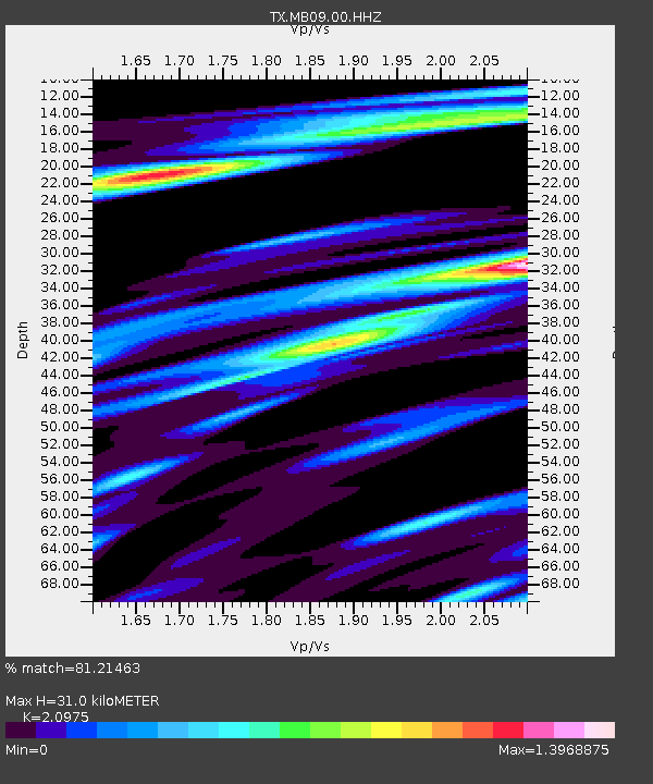
MB09 Lenorah - Earthquake Result Viewer
| Earthquake location: |
Colombia-Ecuador Border Region |
| Earthquake latitude/longitude: |
0.7/-77.8 |
| Earthquake time(UTC): |
2022/07/25 (206) 13:33:28 GMT |
| Earthquake Depth: |
4.0 km |
| Earthquake Magnitude: |
5.7 mww |
| Earthquake Catalog/Contributor: |
NEIC PDE/us |
|
| Network: |
TX Texas Seismological Network |
| Station: |
MB09 Lenorah |
| Lat/Lon: |
32.34 N/101.82 W |
| Elevation: |
798 m |
|
| Distance: |
38.8 deg |
| Az: |
326.651 deg |
| Baz: |
139.506 deg |
| Ray Param: |
0.07541031 |
| Estimated Moho Depth: |
31.0 km |
| Estimated Crust Vp/Vs: |
2.10 |
| Assumed Crust Vp: |
6.426 km/s |
| Estimated Crust Vs: |
3.064 km/s |
| Estimated Crust Poisson's Ratio: |
0.35 |
|
| Radial Match: |
81.21463 % |
| Radial Bump: |
280 |
| Transverse Match: |
48.185387 % |
| Transverse Bump: |
400 |
| SOD ConfigId: |
28764291 |
| Insert Time: |
2022-08-08 13:59:48.307 +0000 |
| GWidth: |
2.5 |
| Max Bumps: |
400 |
| Tol: |
0.001 |
|

Signal To Noise
| Channel | StoN | STA | LTA |
| TX:MB09:00:HHZ:20220725T13:40:23.580014Z | 3.7401993 | 4.3218404E-7 | 1.15551074E-7 |
| TX:MB09:00:HHN:20220725T13:40:23.580014Z | 0.9210726 | 1.7936988E-7 | 1.9474022E-7 |
| TX:MB09:00:HHE:20220725T13:40:23.580014Z | 1.4622027 | 2.3699391E-7 | 1.6208007E-7 |
| Arrivals |
| Ps | 5.6 SECOND |
| PpPs | 14 SECOND |
| PsPs/PpSs | 20 SECOND |


