You are here: Home > Network List > TX - Texas Seismological Network Stations List
> Station PB08 Permian Basin 08 > Earthquake Result Viewer
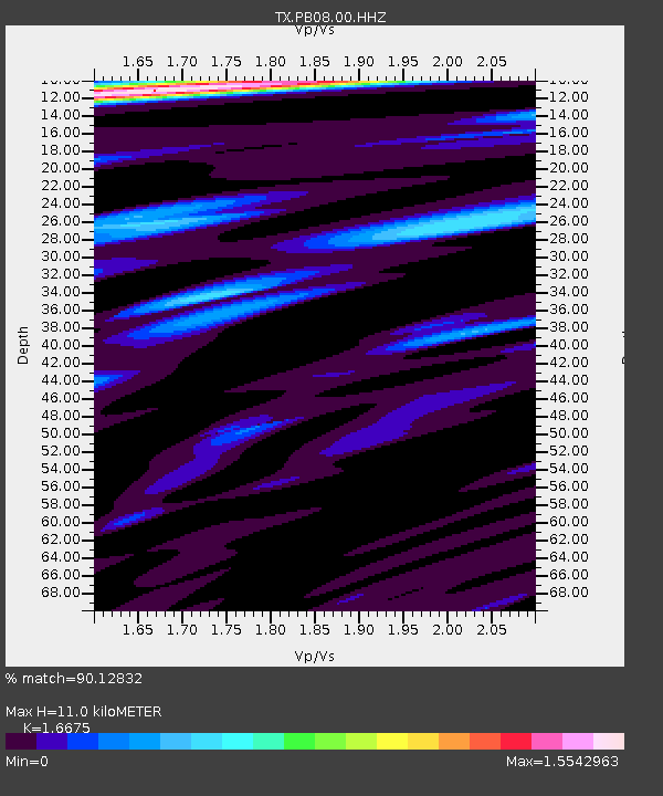
PB08 Permian Basin 08 - Earthquake Result Viewer
| Earthquake location: |
Near Coast Of Venezuela |
| Earthquake latitude/longitude: |
10.9/-62.9 |
| Earthquake time(UTC): |
2018/08/21 (233) 21:31:46 GMT |
| Earthquake Depth: |
154 km |
| Earthquake Magnitude: |
7.3 Mww |
| Earthquake Catalog/Contributor: |
NEIC PDE/us |
|
| Network: |
TX Texas Seismological Network |
| Station: |
PB08 Permian Basin 08 |
| Lat/Lon: |
30.89 N/102.91 W |
| Elevation: |
926 m |
|
| Distance: |
42.1 deg |
| Az: |
304.409 deg |
| Baz: |
109.479 deg |
| Ray Param: |
0.07283304 |
| Estimated Moho Depth: |
11.0 km |
| Estimated Crust Vp/Vs: |
1.67 |
| Assumed Crust Vp: |
6.121 km/s |
| Estimated Crust Vs: |
3.67 km/s |
| Estimated Crust Poisson's Ratio: |
0.22 |
|
| Radial Match: |
90.12832 % |
| Radial Bump: |
400 |
| Transverse Match: |
84.93683 % |
| Transverse Bump: |
400 |
| SOD ConfigId: |
2825771 |
| Insert Time: |
2018-09-04 21:50:10.998 +0000 |
| GWidth: |
2.5 |
| Max Bumps: |
400 |
| Tol: |
0.001 |
|

Signal To Noise
| Channel | StoN | STA | LTA |
| TX:PB08:00:HHZ:20180821T21:38:52.210015Z | 37.135414 | 5.2869495E-6 | 1.4236947E-7 |
| TX:PB08:00:HH1:20180821T21:38:52.210015Z | 2.1637359 | 2.7914248E-7 | 1.2900949E-7 |
| TX:PB08:00:HH2:20180821T21:38:52.210015Z | 10.737039 | 1.5402469E-6 | 1.4345174E-7 |
| Arrivals |
| Ps | 1.3 SECOND |
| PpPs | 4.5 SECOND |
| PsPs/PpSs | 5.8 SECOND |


