You are here: Home > Network List > XK99 - CDROM (Colorado) Stations List
> Station S05B South 05B > Earthquake Result Viewer
S05B South 05B - Earthquake Result Viewer
| Earthquake location: |
Kodiak Island Region, Alaska |
| Earthquake latitude/longitude: |
57.4/-154.5 |
| Earthquake time(UTC): |
1999/12/06 (340) 23:12:33 GMT |
| Earthquake Depth: |
66 km |
| Earthquake Magnitude: |
6.8 MB, 7.0 MW, 7.0 ML |
| Earthquake Catalog/Contributor: |
WHDF/NEIC |
|
| Network: |
XK CDROM (Colorado) |
| Station: |
S05B South 05B |
| Lat/Lon: |
36.85 N/105.41 W |
| Elevation: |
2903 m |
|
| Distance: |
38.1 deg |
| Az: |
101.072 deg |
| Baz: |
318.539 deg |
| Ray Param: |
0.0755374 |
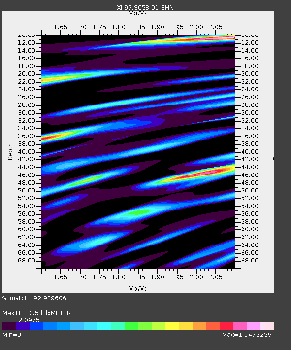
| Estimated Moho Depth: |
10.5 km |
| Estimated Crust Vp/Vs: |
2.10 |
| Assumed Crust Vp: |
6.316 km/s |
| Estimated Crust Vs: |
3.011 km/s |
| Estimated Crust Poisson's Ratio: |
0.35 |
|
| Radial Match: |
92.939606 % |
| Radial Bump: |
400 |
| Transverse Match: |
80.16164 % |
| Transverse Bump: |
400 |
| SOD ConfigId: |
287362 |
| Insert Time: |
2010-03-09 22:45:53.853 +0000 |
| GWidth: |
2.5 |
| Max Bumps: |
400 |
| Tol: |
0.001 |
|

Signal To Noise
| Channel | StoN | STA | LTA |
| XK:S05B:01:BHN:19991206T23:19:16.408007Z | 4.6600842 | 1.0654654E-6 | 2.2863654E-7 |
| XK:S05B:01:BHE:19991206T23:19:16.408007Z | 4.942065 | 1.0064064E-6 | 2.0364085E-7 |
| XK:S05B:01:BHZ:19991206T23:19:16.408007Z | 8.856351 | 2.3704245E-6 | 2.676525E-7 |
| Arrivals |
| Ps | 1.9 SECOND |
| PpPs | 4.9 SECOND |
| PsPs/PpSs | 6.8 SECOND |


