You are here: Home > Network List > XK99 - CDROM (Colorado) Stations List
> Station S05B South 05B > Earthquake Result Viewer
S05B South 05B - Earthquake Result Viewer
| Earthquake location: |
Santiago Del Estero Prov., Arg. |
| Earthquake latitude/longitude: |
-28.3/-63.0 |
| Earthquake time(UTC): |
2000/04/23 (114) 09:27:23 GMT |
| Earthquake Depth: |
608 km |
| Earthquake Magnitude: |
6.6 MB, 7.0 MW, 7.0 MW |
| Earthquake Catalog/Contributor: |
WHDF/NEIC |
|
| Network: |
XK CDROM (Colorado) |
| Station: |
S05B South 05B |
| Lat/Lon: |
36.85 N/105.41 W |
| Elevation: |
2903 m |
|
| Distance: |
76.1 deg |
| Az: |
326.126 deg |
| Baz: |
142.214 deg |
| Ray Param: |
0.04925562 |
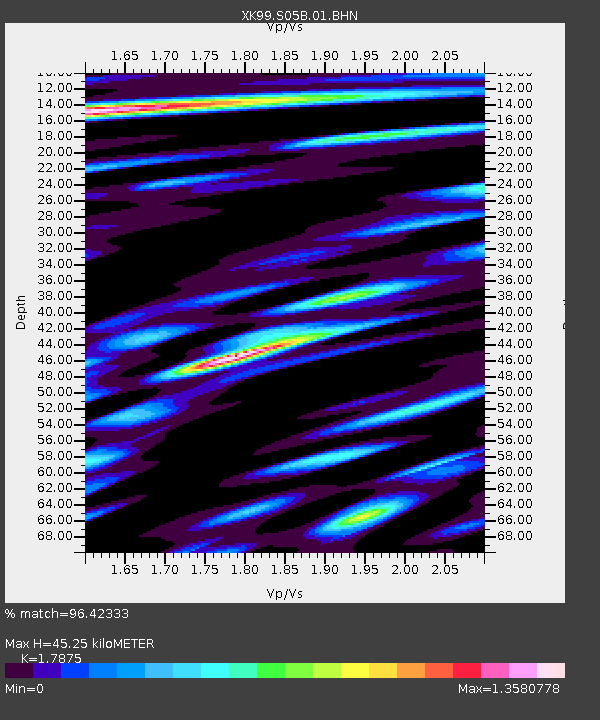
| Estimated Moho Depth: |
45.25 km |
| Estimated Crust Vp/Vs: |
1.79 |
| Assumed Crust Vp: |
6.316 km/s |
| Estimated Crust Vs: |
3.533 km/s |
| Estimated Crust Poisson's Ratio: |
0.27 |
|
| Radial Match: |
96.42333 % |
| Radial Bump: |
400 |
| Transverse Match: |
91.7751 % |
| Transverse Bump: |
400 |
| SOD ConfigId: |
287362 |
| Insert Time: |
2010-03-09 22:45:58.864 +0000 |
| GWidth: |
2.5 |
| Max Bumps: |
400 |
| Tol: |
0.001 |
|

Signal To Noise
| Channel | StoN | STA | LTA |
| XK:S05B:01:BHN:20000423T09:37:38.783013Z | 1.3443549 | 1.7488352E-7 | 1.3008733E-7 |
| XK:S05B:01:BHE:20000423T09:37:38.783013Z | 1.4271551 | 3.088121E-7 | 2.16383E-7 |
| XK:S05B:01:BHZ:20000423T09:37:38.783013Z | 7.452593 | 1.1477803E-6 | 1.5401086E-7 |
| Arrivals |
| Ps | 5.8 SECOND |
| PpPs | 19 SECOND |
| PsPs/PpSs | 25 SECOND |


