You are here: Home > Network List > UW - Pacific Northwest Regional Seismic Network Stations List
> Station SAW St. Andrews, WA, USA > Earthquake Result Viewer
SAW St. Andrews, WA, USA - Earthquake Result Viewer
| Earthquake location: |
Colombia-Ecuador Border Region |
| Earthquake latitude/longitude: |
0.7/-77.8 |
| Earthquake time(UTC): |
2022/07/25 (206) 13:33:28 GMT |
| Earthquake Depth: |
4.0 km |
| Earthquake Magnitude: |
5.7 mww |
| Earthquake Catalog/Contributor: |
NEIC PDE/us |
|
| Network: |
UW Pacific Northwest Regional Seismic Network |
| Station: |
SAW St. Andrews, WA, USA |
| Lat/Lon: |
47.70 N/119.40 W |
| Elevation: |
701 m |
|
| Distance: |
59.1 deg |
| Az: |
328.493 deg |
| Baz: |
129.319 deg |
| Ray Param: |
0.0624473 |
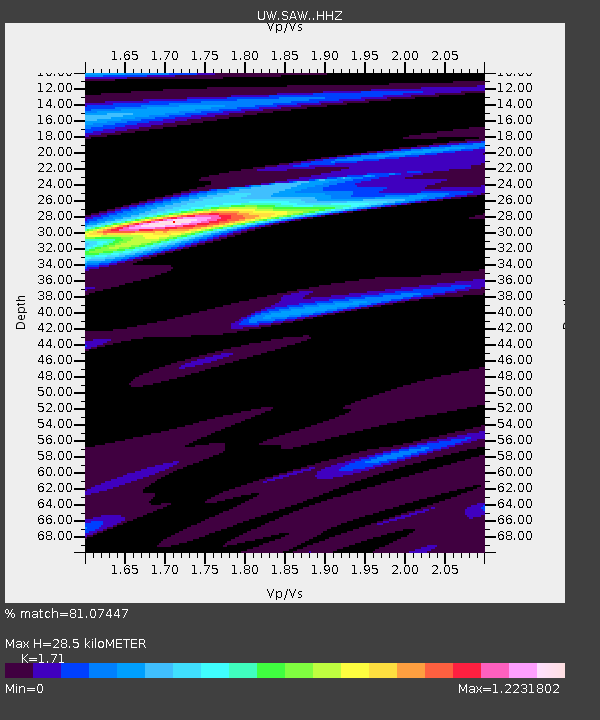
| Estimated Moho Depth: |
28.5 km |
| Estimated Crust Vp/Vs: |
1.71 |
| Assumed Crust Vp: |
6.419 km/s |
| Estimated Crust Vs: |
3.754 km/s |
| Estimated Crust Poisson's Ratio: |
0.24 |
|
| Radial Match: |
81.07447 % |
| Radial Bump: |
297 |
| Transverse Match: |
63.131336 % |
| Transverse Bump: |
303 |
| SOD ConfigId: |
28764291 |
| Insert Time: |
2022-08-08 14:02:53.573 +0000 |
| GWidth: |
2.5 |
| Max Bumps: |
400 |
| Tol: |
0.001 |
|

Signal To Noise
| Channel | StoN | STA | LTA |
| UW:SAW: :HHZ:20220725T13:42:59.000028Z | 3.3672543 | 1.969364E-7 | 5.8485753E-8 |
| UW:SAW: :HHN:20220725T13:42:59.000028Z | 1.6205965 | 8.525744E-8 | 5.2608677E-8 |
| UW:SAW: :HHE:20220725T13:42:59.000028Z | 2.1443377 | 1.1091577E-7 | 5.1724957E-8 |
| Arrivals |
| Ps | 3.3 SECOND |
| PpPs | 11 SECOND |
| PsPs/PpSs | 15 SECOND |


