You are here: Home > Network List > TX - Texas Seismological Network Stations List
> Station PB06 Permian Basin 6 > Earthquake Result Viewer
PB06 Permian Basin 6 - Earthquake Result Viewer
| Earthquake location: |
Near Coast Of Venezuela |
| Earthquake latitude/longitude: |
10.9/-62.9 |
| Earthquake time(UTC): |
2018/08/21 (233) 21:31:46 GMT |
| Earthquake Depth: |
154 km |
| Earthquake Magnitude: |
7.3 Mww |
| Earthquake Catalog/Contributor: |
NEIC PDE/us |
|
| Network: |
TX Texas Seismological Network |
| Station: |
PB06 Permian Basin 6 |
| Lat/Lon: |
31.65 N/103.22 W |
| Elevation: |
831 m |
|
| Distance: |
42.6 deg |
| Az: |
305.329 deg |
| Baz: |
109.998 deg |
| Ray Param: |
0.07251404 |
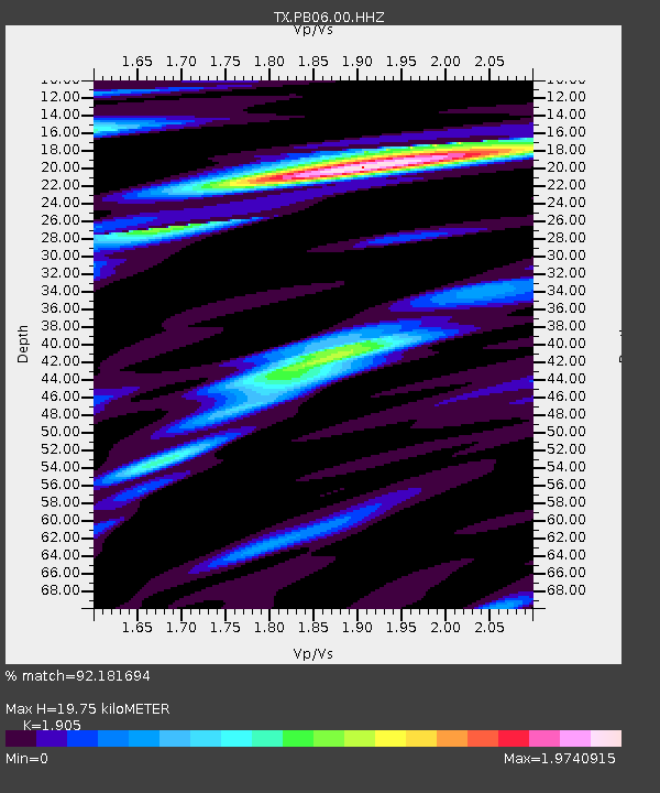
| Estimated Moho Depth: |
19.75 km |
| Estimated Crust Vp/Vs: |
1.90 |
| Assumed Crust Vp: |
6.121 km/s |
| Estimated Crust Vs: |
3.213 km/s |
| Estimated Crust Poisson's Ratio: |
0.31 |
|
| Radial Match: |
92.181694 % |
| Radial Bump: |
400 |
| Transverse Match: |
80.76495 % |
| Transverse Bump: |
400 |
| SOD ConfigId: |
2825771 |
| Insert Time: |
2018-09-04 21:50:25.560 +0000 |
| GWidth: |
2.5 |
| Max Bumps: |
400 |
| Tol: |
0.001 |
|
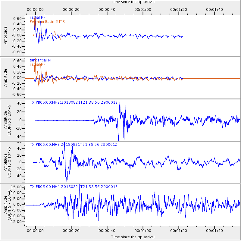
Signal To Noise
| Channel | StoN | STA | LTA |
| TX:PB06:00:HHZ:20180821T21:38:56.290001Z | 55.841343 | 4.9873775E-6 | 8.9313346E-8 |
| TX:PB06:00:HH1:20180821T21:38:56.290001Z | 11.699181 | 6.447039E-7 | 5.5106756E-8 |
| TX:PB06:00:HH2:20180821T21:38:56.290001Z | 42.330673 | 2.907027E-6 | 6.867424E-8 |
| Arrivals |
| Ps | 3.1 SECOND |
| PpPs | 8.9 SECOND |
| PsPs/PpSs | 12 SECOND |


