You are here: Home > Network List > AK - Alaska Regional Network Stations List
> Station D20K Etivluk River, AK, USA > Earthquake Result Viewer
D20K Etivluk River, AK, USA - Earthquake Result Viewer
| Earthquake location: |
Luzon, Philippines |
| Earthquake latitude/longitude: |
17.6/120.8 |
| Earthquake time(UTC): |
2022/07/27 (208) 00:43:24 GMT |
| Earthquake Depth: |
10 km |
| Earthquake Magnitude: |
7.0 Mww |
| Earthquake Catalog/Contributor: |
NEIC PDE/us |
|
| Network: |
AK Alaska Regional Network |
| Station: |
D20K Etivluk River, AK, USA |
| Lat/Lon: |
68.71 N/156.61 W |
| Elevation: |
577 m |
|
| Distance: |
71.1 deg |
| Az: |
22.505 deg |
| Baz: |
269.691 deg |
| Ray Param: |
0.05455355 |
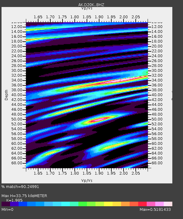
| Estimated Moho Depth: |
33.75 km |
| Estimated Crust Vp/Vs: |
1.99 |
| Assumed Crust Vp: |
6.221 km/s |
| Estimated Crust Vs: |
3.134 km/s |
| Estimated Crust Poisson's Ratio: |
0.33 |
|
| Radial Match: |
90.24991 % |
| Radial Bump: |
400 |
| Transverse Match: |
80.513084 % |
| Transverse Bump: |
400 |
| SOD ConfigId: |
28764291 |
| Insert Time: |
2022-08-10 00:46:08.470 +0000 |
| GWidth: |
2.5 |
| Max Bumps: |
400 |
| Tol: |
0.001 |
|

Signal To Noise
| Channel | StoN | STA | LTA |
| AK:D20K: :BHZ:20220727T00:54:11.439983Z | 13.160885 | 1.7155842E-6 | 1.3035478E-7 |
| AK:D20K: :BHN:20220727T00:54:11.439983Z | 1.5391401 | 2.470889E-7 | 1.6053697E-7 |
| AK:D20K: :BHE:20220727T00:54:11.439983Z | 5.150587 | 7.6719584E-7 | 1.4895309E-7 |
| Arrivals |
| Ps | 5.5 SECOND |
| PpPs | 16 SECOND |
| PsPs/PpSs | 21 SECOND |


