You are here: Home > Network List > US - United States National Seismic Network Stations List
> Station BW06 Boulder Array Site 6 (Pinedale), Wyoming, USA > Earthquake Result Viewer
BW06 Boulder Array Site 6 (Pinedale), Wyoming, USA - Earthquake Result Viewer
| Earthquake location: |
Near Coast Of Venezuela |
| Earthquake latitude/longitude: |
10.9/-62.9 |
| Earthquake time(UTC): |
2018/08/21 (233) 21:31:46 GMT |
| Earthquake Depth: |
154 km |
| Earthquake Magnitude: |
7.3 Mww |
| Earthquake Catalog/Contributor: |
NEIC PDE/us |
|
| Network: |
US United States National Seismic Network |
| Station: |
BW06 Boulder Array Site 6 (Pinedale), Wyoming, USA |
| Lat/Lon: |
42.77 N/109.56 W |
| Elevation: |
2224 m |
|
| Distance: |
51.5 deg |
| Az: |
316.779 deg |
| Baz: |
114.003 deg |
| Ray Param: |
0.06685741 |
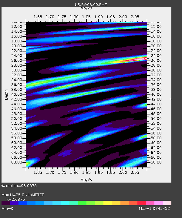
| Estimated Moho Depth: |
25.0 km |
| Estimated Crust Vp/Vs: |
2.09 |
| Assumed Crust Vp: |
6.161 km/s |
| Estimated Crust Vs: |
2.951 km/s |
| Estimated Crust Poisson's Ratio: |
0.35 |
|
| Radial Match: |
96.0378 % |
| Radial Bump: |
400 |
| Transverse Match: |
90.30361 % |
| Transverse Bump: |
400 |
| SOD ConfigId: |
2825771 |
| Insert Time: |
2018-09-04 21:50:45.936 +0000 |
| GWidth: |
2.5 |
| Max Bumps: |
400 |
| Tol: |
0.001 |
|
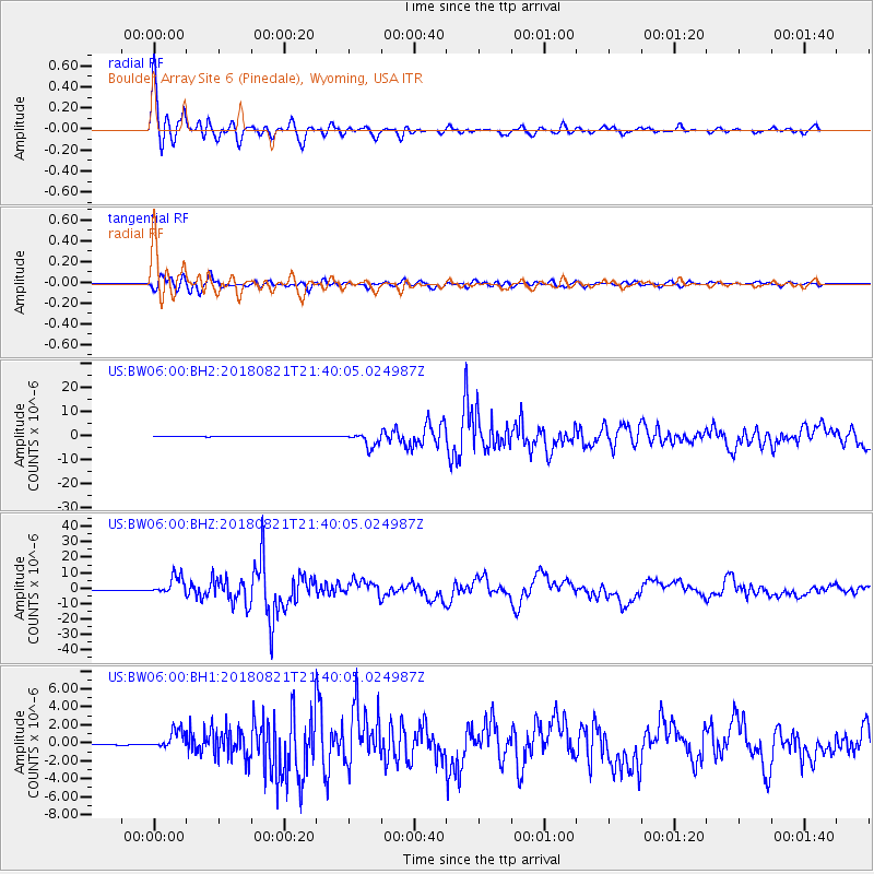
Signal To Noise
| Channel | StoN | STA | LTA |
| US:BW06:00:BHZ:20180821T21:40:05.024987Z | 36.370556 | 5.857881E-6 | 1.610611E-7 |
| US:BW06:00:BH1:20180821T21:40:05.024987Z | 13.759138 | 1.0256956E-6 | 7.4546506E-8 |
| US:BW06:00:BH2:20180821T21:40:05.024987Z | 39.23779 | 2.954734E-6 | 7.530328E-8 |
| Arrivals |
| Ps | 4.6 SECOND |
| PpPs | 12 SECOND |
| PsPs/PpSs | 17 SECOND |


