You are here: Home > Network List > AK - Alaska Regional Network Stations List
> Station R18K Karluk, AK, USA > Earthquake Result Viewer
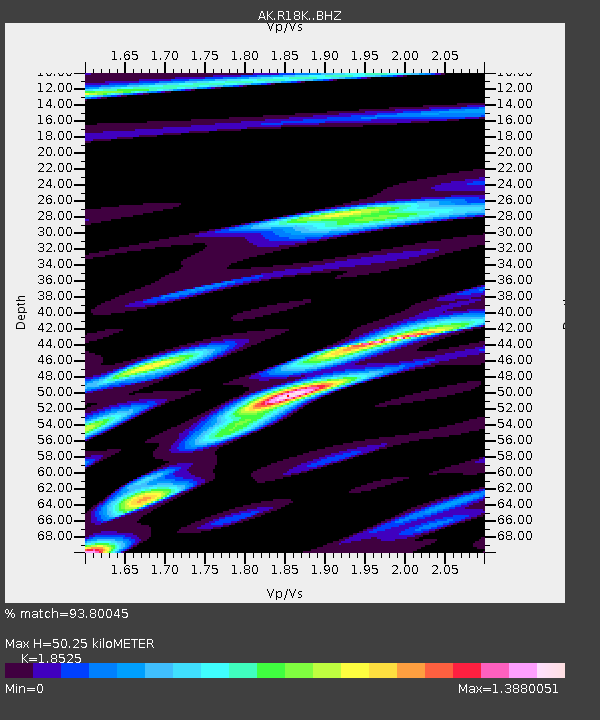
R18K Karluk, AK, USA - Earthquake Result Viewer
| Earthquake location: |
Luzon, Philippines |
| Earthquake latitude/longitude: |
17.6/120.8 |
| Earthquake time(UTC): |
2022/07/27 (208) 00:43:24 GMT |
| Earthquake Depth: |
10 km |
| Earthquake Magnitude: |
7.0 Mww |
| Earthquake Catalog/Contributor: |
NEIC PDE/us |
|
| Network: |
AK Alaska Regional Network |
| Station: |
R18K Karluk, AK, USA |
| Lat/Lon: |
57.57 N/154.45 W |
| Elevation: |
39 m |
|
| Distance: |
72.6 deg |
| Az: |
34.227 deg |
| Baz: |
275.293 deg |
| Ray Param: |
0.05358969 |
| Estimated Moho Depth: |
50.25 km |
| Estimated Crust Vp/Vs: |
1.85 |
| Assumed Crust Vp: |
6.24 km/s |
| Estimated Crust Vs: |
3.368 km/s |
| Estimated Crust Poisson's Ratio: |
0.29 |
|
| Radial Match: |
93.80045 % |
| Radial Bump: |
358 |
| Transverse Match: |
86.24548 % |
| Transverse Bump: |
400 |
| SOD ConfigId: |
28764291 |
| Insert Time: |
2022-08-10 00:48:48.755 +0000 |
| GWidth: |
2.5 |
| Max Bumps: |
400 |
| Tol: |
0.001 |
|

Signal To Noise
| Channel | StoN | STA | LTA |
| AK:R18K: :BHZ:20220727T00:54:20.28001Z | 17.2532 | 1.45248E-6 | 8.418611E-8 |
| AK:R18K: :BHN:20220727T00:54:20.28001Z | 3.7528253 | 4.8478466E-7 | 1.2917859E-7 |
| AK:R18K: :BHE:20220727T00:54:20.28001Z | 4.276214 | 7.004719E-7 | 1.6380656E-7 |
| Arrivals |
| Ps | 7.1 SECOND |
| PpPs | 22 SECOND |
| PsPs/PpSs | 29 SECOND |


