You are here: Home > Network List > AV - Alaska Volcano Observatory Stations List
> Station KIRH Round Head, Kanaga Volcano, Alaska > Earthquake Result Viewer
KIRH Round Head, Kanaga Volcano, Alaska - Earthquake Result Viewer
| Earthquake location: |
Luzon, Philippines |
| Earthquake latitude/longitude: |
17.6/120.8 |
| Earthquake time(UTC): |
2022/07/27 (208) 00:43:24 GMT |
| Earthquake Depth: |
10 km |
| Earthquake Magnitude: |
7.0 Mww |
| Earthquake Catalog/Contributor: |
NEIC PDE/us |
|
| Network: |
AV Alaska Volcano Observatory |
| Station: |
KIRH Round Head, Kanaga Volcano, Alaska |
| Lat/Lon: |
51.90 N/177.09 W |
| Elevation: |
321 m |
|
| Distance: |
59.2 deg |
| Az: |
39.603 deg |
| Baz: |
258.958 deg |
| Ray Param: |
0.062344585 |
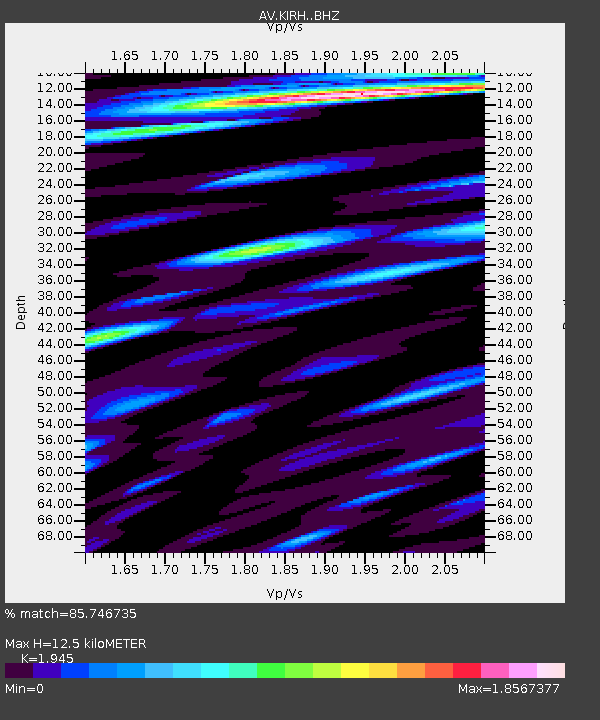
| Estimated Moho Depth: |
12.5 km |
| Estimated Crust Vp/Vs: |
1.95 |
| Assumed Crust Vp: |
5.88 km/s |
| Estimated Crust Vs: |
3.023 km/s |
| Estimated Crust Poisson's Ratio: |
0.32 |
|
| Radial Match: |
85.746735 % |
| Radial Bump: |
400 |
| Transverse Match: |
82.33761 % |
| Transverse Bump: |
400 |
| SOD ConfigId: |
28764291 |
| Insert Time: |
2022-08-10 00:52:41.819 +0000 |
| GWidth: |
2.5 |
| Max Bumps: |
400 |
| Tol: |
0.001 |
|

Signal To Noise
| Channel | StoN | STA | LTA |
| AV:KIRH: :BHZ:20220727T00:52:54.499004Z | 7.603994 | 2.0056714E-6 | 2.6376554E-7 |
| AV:KIRH: :BHN:20220727T00:52:54.499004Z | 2.3212624 | 9.982477E-7 | 4.3004522E-7 |
| AV:KIRH: :BHE:20220727T00:52:54.499004Z | 2.0909717 | 9.586158E-7 | 4.5845474E-7 |
| Arrivals |
| Ps | 2.1 SECOND |
| PpPs | 6.0 SECOND |
| PsPs/PpSs | 8.1 SECOND |


