You are here: Home > Network List > AV - Alaska Volcano Observatory Stations List
> Station MAPS Pakushin Southeast, Makushin Volcano, Alaska > Earthquake Result Viewer
MAPS Pakushin Southeast, Makushin Volcano, Alaska - Earthquake Result Viewer
| Earthquake location: |
Luzon, Philippines |
| Earthquake latitude/longitude: |
17.6/120.8 |
| Earthquake time(UTC): |
2022/07/27 (208) 00:43:24 GMT |
| Earthquake Depth: |
10 km |
| Earthquake Magnitude: |
7.0 Mww |
| Earthquake Catalog/Contributor: |
NEIC PDE/us |
|
| Network: |
AV Alaska Volcano Observatory |
| Station: |
MAPS Pakushin Southeast, Makushin Volcano, Alaska |
| Lat/Lon: |
53.81 N/166.94 W |
| Elevation: |
333 m |
|
| Distance: |
65.6 deg |
| Az: |
38.352 deg |
| Baz: |
266.46 deg |
| Ray Param: |
0.058193285 |
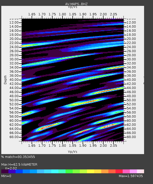
| Estimated Moho Depth: |
62.5 km |
| Estimated Crust Vp/Vs: |
2.02 |
| Assumed Crust Vp: |
3.943 km/s |
| Estimated Crust Vs: |
1.952 km/s |
| Estimated Crust Poisson's Ratio: |
0.34 |
|
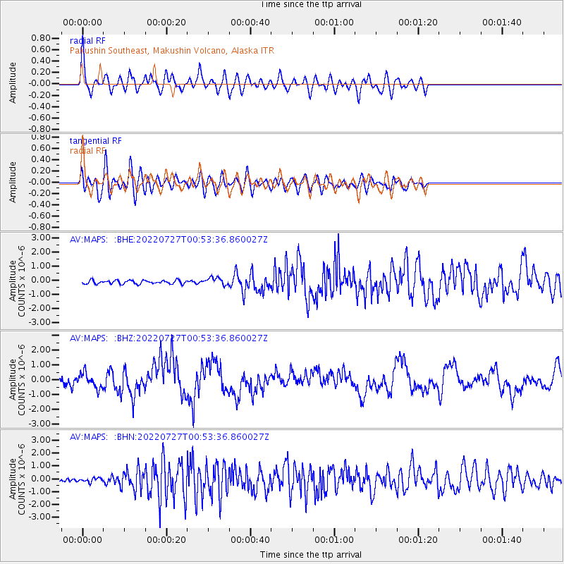
| Radial Match: |
80.353455 % |
| Radial Bump: |
400 |
| Transverse Match: |
65.93089 % |
| Transverse Bump: |
400 |
| SOD ConfigId: |
28764291 |
| Insert Time: |
2022-08-10 00:53:07.940 +0000 |
| GWidth: |
2.5 |
| Max Bumps: |
400 |
| Tol: |
0.001 |
|
Signal To Noise
| Channel | StoN | STA | LTA |
| AV:MAPS: :BHZ:20220727T00:53:36.860027Z | 1.3794185 | 5.117293E-7 | 3.7097465E-7 |
| AV:MAPS: :BHN:20220727T00:53:36.860027Z | 1.361158 | 1.570874E-7 | 1.15407175E-7 |
| AV:MAPS: :BHE:20220727T00:53:36.860027Z | 2.1596692 | 2.7376925E-7 | 1.2676443E-7 |
| Arrivals |
| Ps | 16 SECOND |
| PpPs | 47 SECOND |
| PsPs/PpSs | 64 SECOND |


