You are here: Home > Network List > AV - Alaska Volcano Observatory Stations List
> Station PLBL Mt. Peulik Volcano, Alaska > Earthquake Result Viewer
PLBL Mt. Peulik Volcano, Alaska - Earthquake Result Viewer

| Earthquake location: |
Luzon, Philippines |
| Earthquake latitude/longitude: |
17.6/120.8 |
| Earthquake time(UTC): |
2022/07/27 (208) 00:43:24 GMT |
| Earthquake Depth: |
10 km |
| Earthquake Magnitude: |
7.0 Mww |
| Earthquake Catalog/Contributor: |
NEIC PDE/us |
|
| Network: |
AV Alaska Volcano Observatory |
| Station: |
PLBL Mt. Peulik Volcano, Alaska |
| Lat/Lon: |
57.70 N/156.82 W |
| Elevation: |
461 m |
|
| Distance: |
71.3 deg |
| Az: |
34.188 deg |
| Baz: |
273.284 deg |
| Ray Param: |
0.054432727 |
| Estimated Moho Depth: |
11.0 km |
| Estimated Crust Vp/Vs: |
1.62 |
| Assumed Crust Vp: |
6.1 km/s |
| Estimated Crust Vs: |
3.765 km/s |
| Estimated Crust Poisson's Ratio: |
0.19 |
|
| Radial Match: |
83.6407 % |
| Radial Bump: |
400 |
| Transverse Match: |
75.087135 % |
| Transverse Bump: |
400 |
| SOD ConfigId: |
28764291 |
| Insert Time: |
2022-08-10 00:53:29.847 +0000 |
| GWidth: |
2.5 |
| Max Bumps: |
400 |
| Tol: |
0.001 |
|
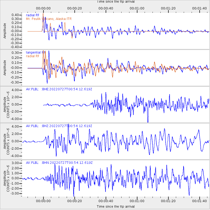
Signal To Noise
| Channel | StoN | STA | LTA |
| AV:PLBL: :BHZ:20220727T00:54:12.619Z | 9.039565 | 8.8323793E-7 | 9.770801E-8 |
| AV:PLBL: :BHN:20220727T00:54:12.619Z | 1.6590495 | 3.4892238E-7 | 2.1031464E-7 |
| AV:PLBL: :BHE:20220727T00:54:12.619Z | 3.8644469 | 5.8566974E-7 | 1.5155331E-7 |
| Arrivals |
| Ps | 1.2 SECOND |
| PpPs | 4.6 SECOND |
| PsPs/PpSs | 5.7 SECOND |


