You are here: Home > Network List > XK99 - CDROM (Colorado) Stations List
> Station S09 South 09 > Earthquake Result Viewer
S09 South 09 - Earthquake Result Viewer
| Earthquake location: |
Tonga Islands |
| Earthquake latitude/longitude: |
-16.9/-174.2 |
| Earthquake time(UTC): |
2000/01/08 (008) 16:47:20 GMT |
| Earthquake Depth: |
183 km |
| Earthquake Magnitude: |
6.5 MB, 6.6 MS, 7.2 MW, 7.0 ME |
| Earthquake Catalog/Contributor: |
WHDF/NEIC |
|
| Network: |
XK CDROM (Colorado) |
| Station: |
S09 South 09 |
| Lat/Lon: |
36.51 N/105.30 W |
| Elevation: |
2578 m |
|
| Distance: |
83.9 deg |
| Az: |
49.12 deg |
| Baz: |
243.943 deg |
| Ray Param: |
0.045402247 |
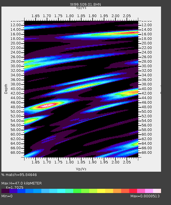
| Estimated Moho Depth: |
47.0 km |
| Estimated Crust Vp/Vs: |
1.70 |
| Assumed Crust Vp: |
6.316 km/s |
| Estimated Crust Vs: |
3.71 km/s |
| Estimated Crust Poisson's Ratio: |
0.24 |
|
| Radial Match: |
95.84646 % |
| Radial Bump: |
400 |
| Transverse Match: |
83.0155 % |
| Transverse Bump: |
400 |
| SOD ConfigId: |
287362 |
| Insert Time: |
2010-03-09 22:47:20.952 +0000 |
| GWidth: |
2.5 |
| Max Bumps: |
400 |
| Tol: |
0.001 |
|

Signal To Noise
| Channel | StoN | STA | LTA |
| XK:S09:01:BHN:20000108T16:58:58.809004Z | 1.238773 | 3.1707978E-7 | 2.559628E-7 |
| XK:S09:01:BHE:20000108T16:58:58.809004Z | 2.6059134 | 5.329006E-7 | 2.0449667E-7 |
| XK:S09:01:BHZ:20000108T16:58:58.809004Z | 11.524114 | 2.0537627E-6 | 1.7821436E-7 |
| Arrivals |
| Ps | 5.4 SECOND |
| PpPs | 20 SECOND |
| PsPs/PpSs | 25 SECOND |


