You are here: Home > Network List > CC - Cascade Chain Volcano Monitoring Stations List
> Station SWF2 Southwest Flank moved down hill, Mt. St. Helens, WA > Earthquake Result Viewer
SWF2 Southwest Flank moved down hill, Mt. St. Helens, WA - Earthquake Result Viewer
| Earthquake location: |
Luzon, Philippines |
| Earthquake latitude/longitude: |
17.6/120.8 |
| Earthquake time(UTC): |
2022/07/27 (208) 00:43:24 GMT |
| Earthquake Depth: |
10 km |
| Earthquake Magnitude: |
7.0 Mww |
| Earthquake Catalog/Contributor: |
NEIC PDE/us |
|
| Network: |
CC Cascade Chain Volcano Monitoring |
| Station: |
SWF2 Southwest Flank moved down hill, Mt. St. Helens, WA |
| Lat/Lon: |
46.18 N/122.22 W |
| Elevation: |
1548 m |
|
| Distance: |
94.9 deg |
| Az: |
38.422 deg |
| Baz: |
301.435 deg |
| Ray Param: |
0.040936556 |
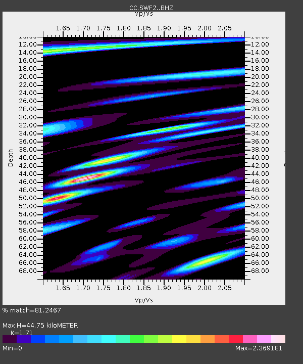
| Estimated Moho Depth: |
44.75 km |
| Estimated Crust Vp/Vs: |
1.71 |
| Assumed Crust Vp: |
6.566 km/s |
| Estimated Crust Vs: |
3.84 km/s |
| Estimated Crust Poisson's Ratio: |
0.24 |
|
| Radial Match: |
81.2467 % |
| Radial Bump: |
400 |
| Transverse Match: |
72.46296 % |
| Transverse Bump: |
400 |
| SOD ConfigId: |
28764291 |
| Insert Time: |
2022-08-10 00:56:35.427 +0000 |
| GWidth: |
2.5 |
| Max Bumps: |
400 |
| Tol: |
0.001 |
|

Signal To Noise
| Channel | StoN | STA | LTA |
| CC:SWF2: :BHZ:20220727T00:56:14.840008Z | 2.4622545 | 4.82918E-7 | 1.9612837E-7 |
| CC:SWF2: :BHN:20220727T00:56:14.840008Z | 0.900633 | 1.5649873E-7 | 1.7376526E-7 |
| CC:SWF2: :BHE:20220727T00:56:14.840008Z | 1.409771 | 3.4868373E-7 | 2.4733362E-7 |
| Arrivals |
| Ps | 4.9 SECOND |
| PpPs | 18 SECOND |
| PsPs/PpSs | 23 SECOND |


